I’m honestly astonished I’ve not done this before. Following last month’s real itinerary, how not to do the Ring Road, I’m finally going to do something I thought I must have done by now, an actual full Ring Road itinerary. Ideally, you want the entire summer because there’s so much to do in Iceland that you simply can’t do it in one trip but I’ve marked off a selection of the things you’ll see on Instagram and a collection of the things I personally enjoy and I’ve squeezed it into ten days. Ten days was hard! I was very proud of myself initially for getting it into fifteen until I realised it was 50% too long. Getting into ten days means long days and you’ll come back far more tired than when you set off for your holiday but it’s just about feasible. It’s 2,516km or 1,563 miles in total – which is actually a little less than I did in August and it’s spread over 10 days instead of 8 but yeah, some of them are long days. If you can manage two or even three weeks, you’ll have time to see everything and breathe too. This is the Ultimate Iceland Ring Road Itinerary.
day – region – distance driven (km/miles), driving time
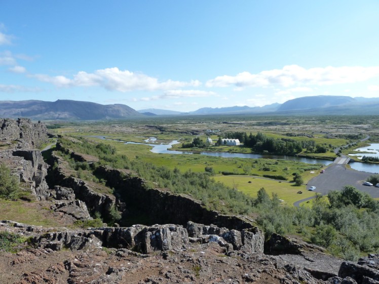
Day one: the Golden Circle (distance: depends where you start and what stops you make but from Hveragerdi, covering the three most important stops and finishing at the campsite at Þingvellir, 154km / 96 miles, 2h 9 m)
Now, I dithered over day one. Am I assuming you’re coming in on an overnight flight ready to set off by 7am? Am I assuming you’re starting in the afternoon after a lunchtime flight? Or am I assuming you got in late the day before and you’re ready to get going in the morning. Well, I’m assuming that the Golden Circle is the best place to start in all three cases. If you’re starting in the morning, whether you’re starting from the airport or from the hotel where you spent last night in Reykjavik, you’ve got plenty of time to cover the Golden Circle. If you’re starting from the afternoon, condense it a bit. I’ve added in some extras to give you options.
So, the Golden Circle. The three important stops are Þingvellir, Gullfoss and Geysir. There are also two geothermal lagoons, if you’ve got the time or inclination to stop at either, and there are various other interesting things to look at or places to eat along the way. The route is so-called because you’re supposed to make a circle between the three big stops, starting and finishing in Reykjavik. Obviously, you don’t have to do it as a circle and if you’ve got your own car – which this post assumes you do – you can go where you like. You can read my Icelandic Guidebook post on the Golden Circle but the highlights go like this:
- Þingvellir is a National Park, rift valley, home of Iceland’s Parliament between 930 and 1798. It’s got cliffs and plains and lakes and views and it’s worth visiting.
- Gullfoss is a huge waterfall which falls in two big steps into a narrow canyon, sending up clouds of spray.
- Geysir is a geothermal field featuring many bubbling boiling pools, the original but dormant Geysir himself and the current active geyser Strokkur, which erupts every 5-10 minutes.
Day two: the west (415km / 258 miles, 5h 33m)
On your second day, head up to the west, towards the Whale Fjord. I like to drive around it because it’s very beautiful and very peaceful – very few tourists bother when there’s the tunnel to cut through. That’ll take a good half an hour off your driving time if you want to shrink your day down a bit. You can pause at Akranes for a dip in Guðlaug Baths if you want. There’s another hot springs opportunity later on but Guðlaug is a lot cheaper, which works out better for a quick dip.
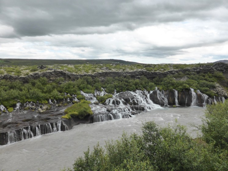
Head up to Borgarnes, into the old town and down to the end of the peninsula to the Settlement Centre. If you think you’ve got time, absolutely do the Settlement exhibit but whatever you do, don’t miss the one on Egil’s Saga. Then you’re going to head east, inland, towards some of Iceland’s historic sagaland. Stop at Reykholt for the Snorri Sturlusson museum and you can keep going out to the waterfall twins, Hraunfossar and Bjarnarfoss. The former is a lot of small waterfalls pouring out of the side of the riverbank from under the lavafield and the latter is a fierce waterfall throwing itself through a small but very narrow and twisted canyon. Head back to the Ring Road, stopping at Deildartunguhver, Europe’s biggest hot spring. It’s worth seeing in itself but you could also stop at Krauma, the geothermal pool complex fed by said spring.
Back on the Ring Road, you’re now going to head for Snæfellsnes. I always regret not taking two days for this so you’re definitely not going to do the whole thing after spending part of the day exploring the west. I’m going to leave you to find your own campsite or hotel but I’d recommend doing Gerðuberg, an inland cliff of basalt columns, the fishing village Arnarstapi and black sand beach Djúpalónssandur.
Day three: the north-west (416km / 258 miles, 5h 31m)
Today you’re going to finish Snæfellsnes. There are lot of little fishing villages along its north coast but the obvious stops are Kirkjufell, the famous shark-fin-shaped mountain, and Stykkishólmur. Don’t take too long but now you’ve got a good long drive to Akureyri. There are plenty of places to stop along the way – the Icelandic Seal Centre at Hvammstangi, lots of little country churches, mountain passes etc but it’s quite a long driving day.
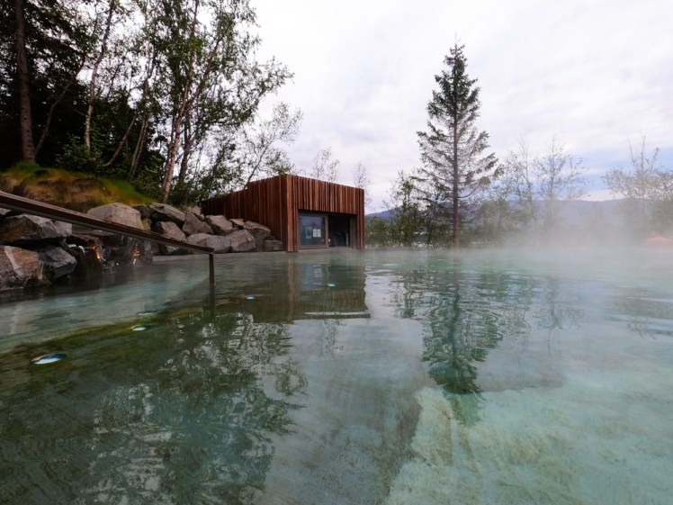
When you get to Akureyri, find yourself a bed for the night and get to the Forest Lagoon. It’s a great way to finish a day, especially after a long drive.
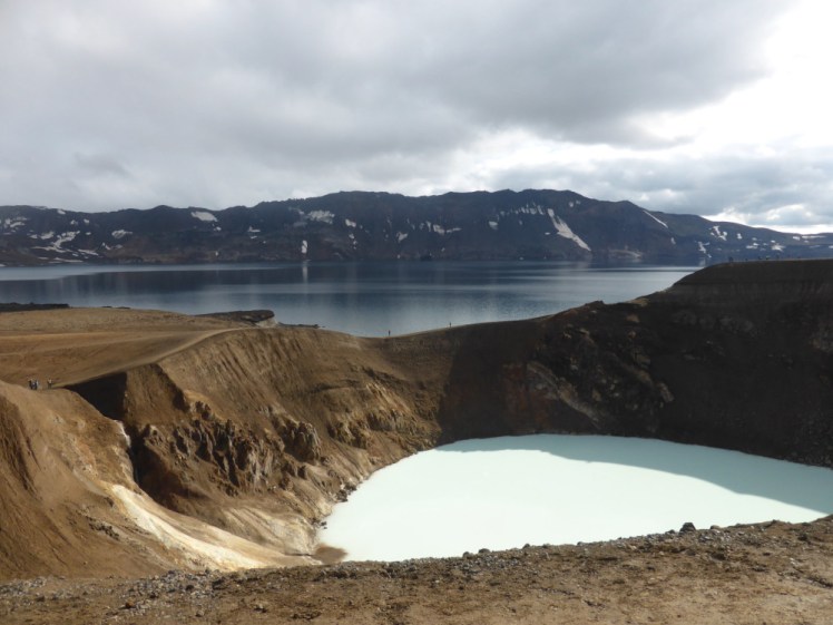
Day four: Myvatn & the north (276km / 172 miles, 3h 51m)
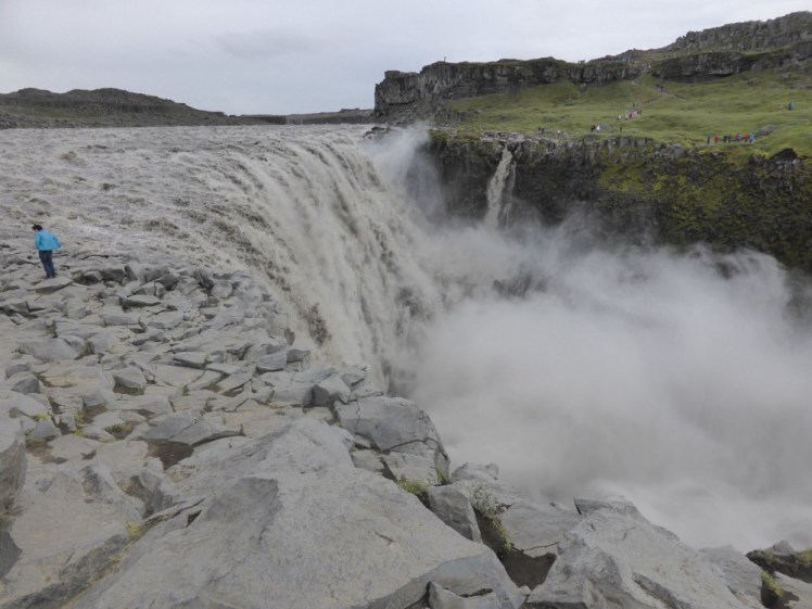
Honestly, I could make a week-long itinerary just out of this region. It’s about an hour, hour and half to drive from Akureyri to Myvatn. Make a stop at Goðafoss on the way, you’ll drive right past it. Base yourself in Reykjahlíð for the next two nights. Start with the Diamond Circle – a trip up to Husavik (maybe with time for a whale-watching trip), across to Ásbyrgi, which is a vast horseshoe-shaped canyon and then down to Dettifoss. You have to pick either the east side or the west side – there’s no changing your mind in the middle. I like the east side myself – it’s all very grey and apocalyptic and the waterfall is just laid out in front of you, so close you can paddle at the top of it – don’t do this, it’s incredibly dangerous and incredibly stupid! The west side is greener, less awkward underfoot and probably the more popular side but I think you get a better view of the waterfall from the east.
Keep heading south, back to the Ring Road. Turn right to head back to Myvatn. You have so many choices here. Hverir is a field of hot springs, bubbling mud, boiling “kettles” and scorched earth. Across the road, you can drive up to the Krafla region, passing an eternal shower and the power station. Up the top, there’s a viewpoint, a flooded canyon full of blue water and my favourite lava field, Leirhnjúkur, which is still steaming after eruptions in the late 70s/early 80s.
Back down by the lake, you’ve got Dimmuborgir, the Dark Cities, a weird lava field of twisted shapes inhabited by the Yule Lads. You’ve got Skútustaðir, where pseudocraters popped up on the marsh a few thousand years ago. You’ve got Grjótagjá, a cave flooded with hot blue water where you can swim if you want to ignore the guidance on heat and acidity (this is my way of saying “don’t swim in it”). If you want to swim somewhere safe, there’s the Myvatn Nature Baths – the Blue Lagoon in miniature and dare I say it, better than the Blue Lagoon.
Day five – Askja expedition (13km / 8 miles, 18 m)
You’ll need a tour for this. Getting to Askja involves driving across a very inhospitable lava field and at least three river crossings, to say nothing of the navigation. Whoever you book it with, ultimately it’ll be with Myvatn Tours and you have the choice of going in the big high-clearance coach (cheapest option) or in a superjeep (much smaller group but more expensive) or possibly even a private tour (most expensive!). This is a summer-only trip and in this part of Iceland, summer really means July to late August. If you haven’t read my Askja post from this summer, it involves hiking two and a half kilometres across a volcanic caldera to a flooded newer caldera and a (potentially swimmable) flooded explosion crater. It’s a good trip to do, especially as there’s a possibility that Askja is gearing up for an eruption that will change its surface forever.
This is a long day – you’ll be setting off about 7.30am and the shortest trip won’t get back until 7.30pm at the earliest, so don’t plan to do much else today. I found time to spend two or three hours in Myvatn Nature Baths but there’s no guarantee you will. But keep it in mind as a possibility if you didn’t have time yesterday.
Day six – the east (287km / 178 miles / 3h 48m)
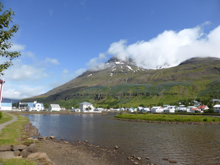
It’s a bit of a drive to Egilsstaðir from Myvatn but not too bad. Satnav should say about two hours. Mine took more like three but I stopped a lot. This is a particularly spectacularly bare part of the country and worth looking at.
I think you’ve probably got time to pick one or the other of these two options but if you can squeeze both in, do. If you drive down the lake, you’ll come to Hengifoss, a waterfall at the top of a mountain ridge which falls into a red-striped bite in the landscape. It’ll take an hour or two to walk up and you’ll pass a smaller waterfall tumbling among brown basalt columns on your way up.
Or drive down to Seyðisfjörður, generally appreciated as one of the prettiest villages or small towns in the region. You’ve seen Seyðisfjörður dozens of times. It’s got the rainbow road and the corrugated iron-clad blue church and the gorgeous fjord views. It’s where the ferry from Denmark comes in.
I’m also, personally, quite fond of Reyðarfjörður and Eskifjörður, which are two more fjord-side villages. There’s an amazing viewpoint on the mountain that separates the two and Eskifjörður has a really nice pool in the dip between two steep mountains.
If by some miracle you still have time to kill, you can always go for a dip in Vök Baths, Iceland’s only floating infinity pools – but honestly, I prefer just about any other geothermal pool and the municipal pool in Egilsstaðir is perfectly pleasant.
Day seven – Jökulsárlón and the south-east (313km / 195 miles, 4h 21m)
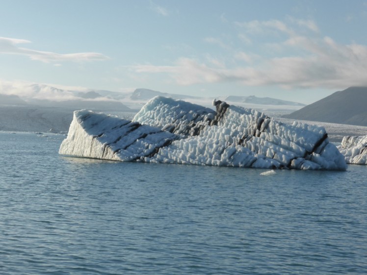
This is another long day. You can shortcut via the 95/939 instead of following the Ring Road around several fjords but be warned that it’s a gravel road, very steep in a couple of places, prone to fog and likely to be closed in bad weather. That said, it’s very different from anything you’ll see anywhere else and while the fjord road is pretty, you’re going to see plenty of fjord roads. Keep going under the edge of Vatnajökull, Europe’s biggest glacier and in a few hours, you’ll find yourself at Jökulsárlón, the famous glacier lagoon. From here, you can enjoy the views from the side or from the gravel car parks further along the road; you can go out on a slow amphibious boat or zoom around on one of the Zodiac RIBS; or my favourite option is to kayak. It’s probably best to book any kind of boat trip in advance. I got lucky on of the last amphibians of the day but the Zodiacs were sold out and that was in 2016, when tourist numbers weren’t quite what they are today.
It’s another 45-60 minutes west to Skaftafell, which is a great place to camp, nestled between three glaciers. Depending on what time you get here, you could hike up to Svartifoss, which is a beautiful waterfall in a hole in the trees, falling over its own fringe of black basalt columns, which takes an hour and a half to two hours round trip. You can also walk along the edge of the mountain through meadows to Skaftafellsjökull, the nearest glacial tongue. That’s a nice trip to keep for a sunny evening. Be warned; Skaftafell is a great place to camp but you will need a mallet to get those tent pegs in.
Day eight – the south coast (460km / 286 miles, 6h 3m)
Day eight and we’re driving fairly slowly west to Hveragerði. It’s another big day but tourists do day trips from Reykjavik and back to Skaftafell and if they can manage that, you can manage most of it in one direction only. You’ll want to make a few stops. Vik is the first and most obvious – it has a black sand beach, a big souvenir outlet and the Lava Show, the first indoor lava theatre experience in the world (for very obvious reasons – who would ever think to combine lava and theatre?). Around the headland is Reynisfjara, the famous and beautiful black sand beach. Unlike Vik’s beach, you’ll be sharing this one with hundreds of tourists and almost as many warning signs. Please pay heed to them; they’re trying to stop you being dragged out to sea and drowned by extremely dangerous waves.
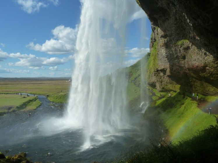
Next stop, Skogafoss, a big wide square and very powerful waterfall. If you want, you can detour into the mountain a little way up the road to find Seljavallalaug, Iceland’s oldest and wildest swimming pool. A little further on is Seljalandsfoss, a beautiful lacy waterfall which has eaten a cave into the rock behind it – this is the one you can walk behind.
If you’ve got a spare day, you can turn left here and drive down to the ferry port for a trip over to Heimaey, a small island dominated by a volcano that tried to destroy the town in 1973. The islanders fought back.
There’s nothing major to stop for between Seljalandsfoss and Hveragerði, just mile after mile of pleasant meadow land and the sense that you’re returning to civilisation. The campsite at Selfoss is nice; huge and with hot tubs hidden away behind reception. Hveragerði has a good campsite (not enough toilets but when are there ever?) and it’s a short walk to the local pool but it doesn’t have hot tubs, so if you want to cut 10-20 minutes off your day today, camp here instead.
Day nine – Hveragerði (12km / 7 miles, 22m)
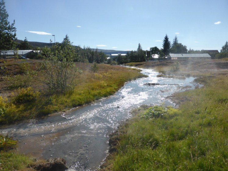
Hveragerði is a good place to catch your breath. You’ve already done the Golden Circle, so you don’t need to rush off and see the region but you can still keep yourself busy with some uniquely Icelandic things. This area is very geothermally active, so there are greenhouses full of fresh produce, you can buy “volcano bread” in the bakery down at the supermarket complex and there’s the Geothermal Park halfway through town. Actually, that’s a bit underwhelming. The hotspot has moved on and a lot of the bubbling mud and hot streams have cooled down and dried up. But if you’re after real natural geothermal wonders, there’s a 6km round hike up into the mountains to a hot river where you can bathe. If it’s been raining heavily lately, this will most likely be stone cold – word of warning. It was when I went up there. It’s a very vertical 6km so it’ll probably take longer than you expected but if the weather’s been nice, that hot river is amazing.
If hiking into the mountains isn’t your thing, you can go up the road to Eldhestar, a stable where you can have a ride on an Icelandic horse. They offer various trips depending on your level of experience.
And if you’re not into horses either, this might be a good day to run back down the road to hop over to Heimaey.
Day ten – Reykjanes (ending at Blue Lagoon; I don’t know where your day is going to actually end, 170km / 106 miles, 2h 40m)
Last day! Go straight across the roundabout as you leave Hveragerði, follow the 38 south-west and then the 427 along the south coast of the Reykjanes peninsula. There’s a lot to see and do along here. By the time you’re there, there may be another eruption – one is forecast for any time in the coming days and weeks. If there is, Safetravel is probably your best bet for finding out how to visit it safely.
If not, you’ve got the eruption sites from 2021, 22 and 23 (collectively known as Fagradalsfjall but increasingly awkward to get at) which you can visit. They’re cold and greying but still pretty spectacular. There are the hot springs sites at Krysuvik and Gunnuhver – Krysuvik is more along the lines of blue mud, orange sulphurous patches and hot streams, whereas Gunnuhver is mostly an enormous cloud of furious steam caused by a malevolent ghost. Brimketill, a concave cliff that funnels big waves up into a huge splash is always fun to watch from a distance, especially in bad weather.
Down at Reykjanesta, you can see the keyboards from the Eurovision movie I still haven’t seen, and get views out over the sea and hundreds of sea birds. There’s always the Bridge Between the Continents, a steel bridge that connects two mini-cliffs, purporting to be two sides of different tectonic plates – I’d like to emphasise that this is entirely symbolic and these are not the edges of the plates. If you’ve actually driven this itinerary, you’ve crossed the boundary between the two plates a dozen times by now without even noticing.
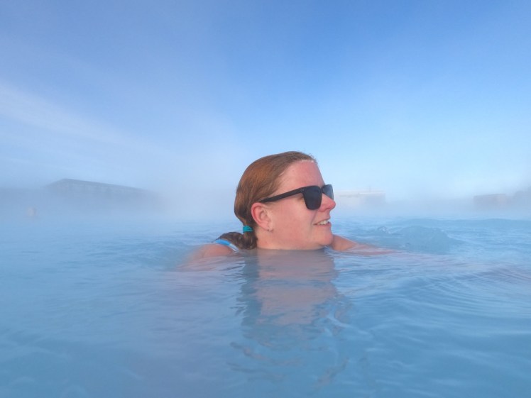
And last but not least, the Blue Lagoon. Do I need to say anything about it? No. It’s just a gorgeous place to finish a trip around the Ring Road before you get your flight.
