And for the second part of my new Icelandic Guidebook series, I’m going to introduce you to the south west’s most popular day trip: the Golden Circle.
The Golden Circle is really the tourist tag for a route that takes in Þingvellir, Geysir and Gullfoss. There are plenty of other stops according to the whim of your driver or guide but 99% of Golden Circle trips will include those three.
The practicalities
First, let’s run over how you actually visit the Golden Circle. If you’re hiring a car, you can obviously drive yourself. I’m of the opinion that you don’t need a satnav – the sort of paper map provided by your car hire company will do the job. There aren’t many roads and the Golden Circle sights are pretty well signposted. Take a full day. Even better, take two days.
If you’re not hiring a car, all the tour companies do bus trips, ranging from all-day eleven hour epics to a quick evening dash. For a start, see what Grayline and Reykjavik Excursions have to offer.
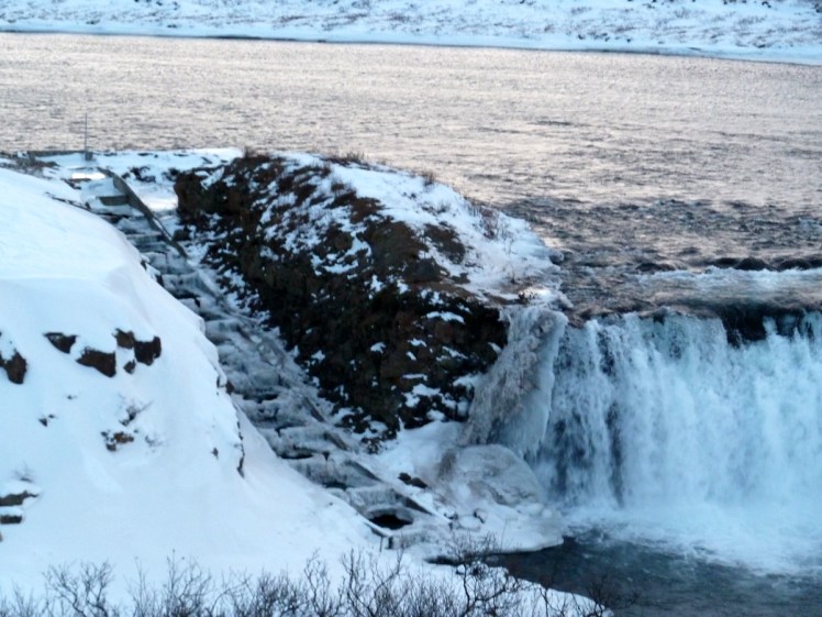
Gullfoss
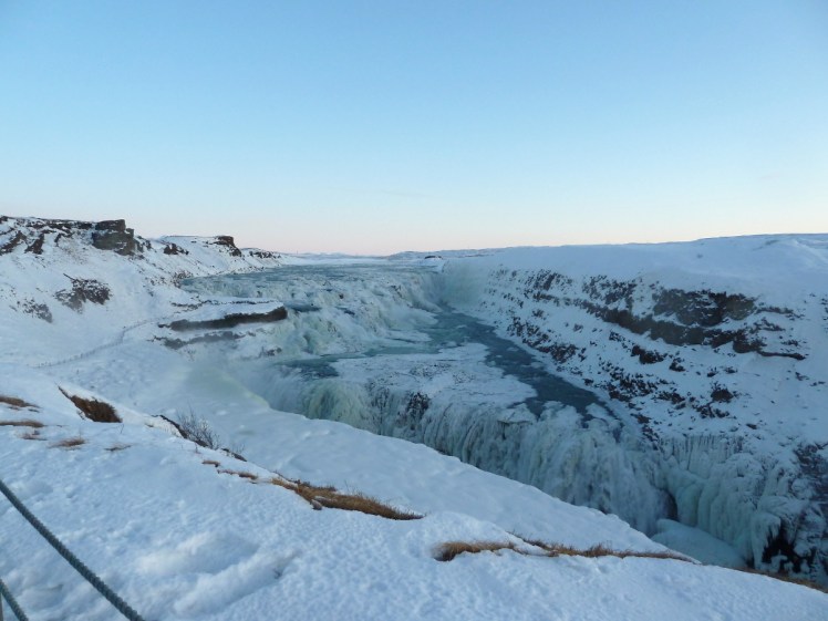
Gullfoss is a big two-step waterfall in the Hvitá river. In English, that Golden Waterfall in the White River. Gullfoss actually turns with each fall so the width of the falling water is getting on for double the width of the river itself and the second step falls into a steep-sided canyon. The spray that comes up in winter makes it impossible to see the bottom.

If you follow the path behind the visitor centre, it’ll take you to a viewpoint and then to a path that runs out to the bit of rock sticking out into the fall. Be careful; it’s wet and slippery and Iceland’s opinion is that a low rope is perfectly adequate protection. You can park in the lower car park to avoid the wooden steps down to clifftop level but it’s a smaller car park and you’ll have to climb up the steps for the visitor centre.
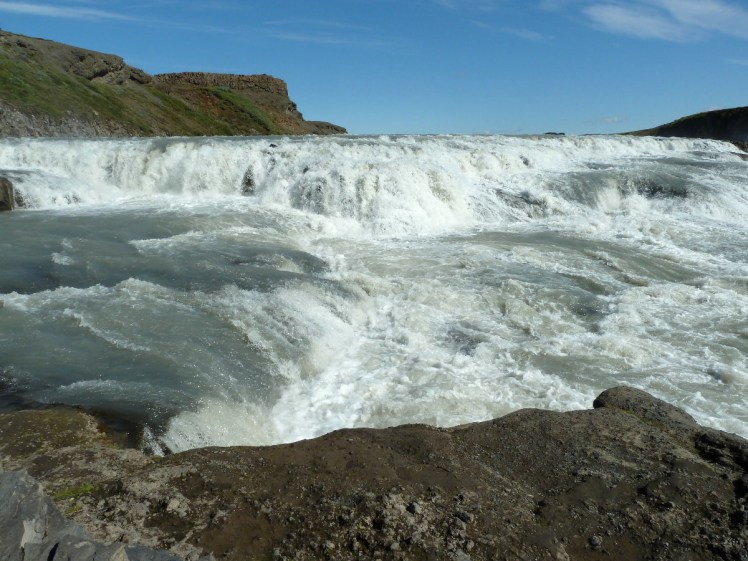
The two drops in total come to 32m. The top one is 11m and you’ll just have to take my word for it that the bottom one is 21m because, as I said, you can’t see all of it. Average flow is about 140 cubic metres per second in summer and 80 in winter. Astonishingly, in winter, most of this enormous waterfall freezes. In severe floods, flow rate can reach 2000 cubic meters per second, or the equivalent of an Olympic swimming pool falling over the edge every second.
Gullfoss is often the lunch stop because it has a large visitor centre with a cafe. Lamb soup is generally the order of the day or you can grab a coffee and a bar of chocolate. Take a few minutes in the gift shop as well – I have some great little felt Christmas tree decorations from here, as well as my Cintamani headband. I’ll forever be tempted by the really expensive real wool clothes too.
Take a moment out in the car park to appreciate Langjökull glistening on the horizon. It’s Iceland’s second largest glacier and there are various tours to go and visit it. If you’ve got your own car, don’t be tempted. Beyond Gullfoss, the road becomes an F road, which means 4×4 non-hire cars only.
Geysir
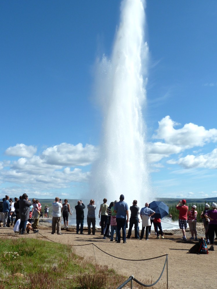
Also occasionally known as the Haukadalur Geothermal Field, this is where you’ll come face to face with Iceland’s tectonic excitements. The English name for an erupting hot spring, geyser, comes from here – specifically from the big quiet one called Geysir, which means gusher. In British English, it’s generally pronounced geezer, in American English guy-zer and in Icelandic, gay-seer.
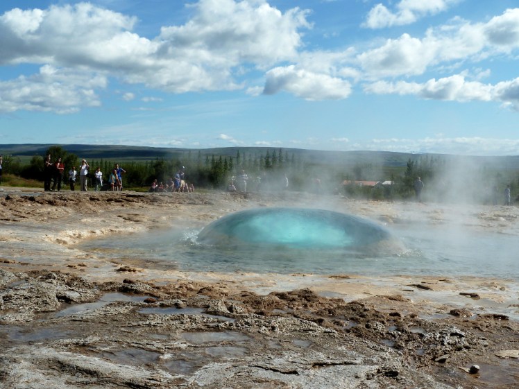
Geysir himself used to erupt pretty regularly. Then for a few decades it could be induced with a lot of soap powder for special occasions. These days, eruptions are rare to the point of unknown. Luckily, Strokkur (the Churn) has come awake and it sends a 20m explosion of boiling water in the sky every five or ten minutes. You’ll soon find it. It’s the one with the ring of tourists around it that keeps exploding. Don’t cross the low rope here – you do not want to be sprayed by thousands of litres of boiling water. In fact, don’t cross the low ropes anywhere. Even the quietest calmest pool in this valley is hot enough to take your skin off and so are plenty of the little streams that run across the paths. Strokkur often does double eruptions and occasionally even a triple one, so don’t put your camera down after the first. The second is usually smaller and the rare third is a lot smaller but it’s still worth catching.
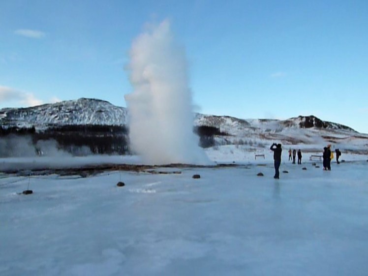
If you look really closely, you’ll see a big doughnut shaped bubble of blue water form in Strokkur’s pool a split second before the eruption tears through it. I have around 200 photos of a bubbling pool in order to catch two photos of that bubble because there’s no warning whatsoever that a bubble and eruption are about to happen.
Stay long enough to appreciate Strokkur a few times but have a wander around the other pools. Some are clear, some are opaque. Some are silver, some are blue. Some are absolutely still, some slosh violently and some merely simmer with a steamy haze on their surface. Stay on the path side of the ropes. I have no idea how deep these pools are but I suspect the answer is very and you don’t want to find out first-hand.
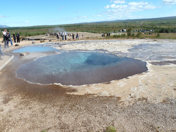
You can climb up the hill behind all the hot pools as well, if you’ve got time, for a view over the entire area. This is what Iceland refers to as a “low temperature area”. I know, it sounds mad. A “high temperature area” is hot enough for boreholes to power geothermal power stations. A “low temperature area” is merely hot enough to be an interesting tourist spot.
A warning: tour buses tend to rush you through here, with just enough time to walk from the top to the bottom and catch an eruption or two. It’s a shame, because it’s well worth spending some time here.
On the other side of the road is another visitor centre with a cafe. I think this cafe has been enlarged since the last time I ambled through it and if the tour buses are still in the habit of lunching at Gullfoss, this one might be a little quieter. There’s fuel available here too, and a hotel and campsite next door. One day I’m absolutely camping here so I can watch Strokkur erupt alone in the long white night.
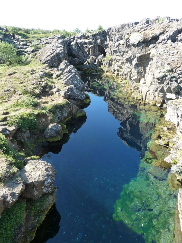
Þingvellir
Þingvellir is my favourite stop on the Golden Circle. Let’s go over its pronunciation first. That weird letter at the beginning isn’t a P, it’s a thorn, a letter we don’t have in English anymore. It’s pronounced th, the same as the th at the beginning of thorn. A double-l in Icelandic is very similar to a double-l in Welsh. If you don’t speak Welsh, then a sound somewhere between tl and cl will make it sound like you’ve made an effort with the language. Thing-vetlir. It’s not perfect but it’s better than a lot of tourists will manage.
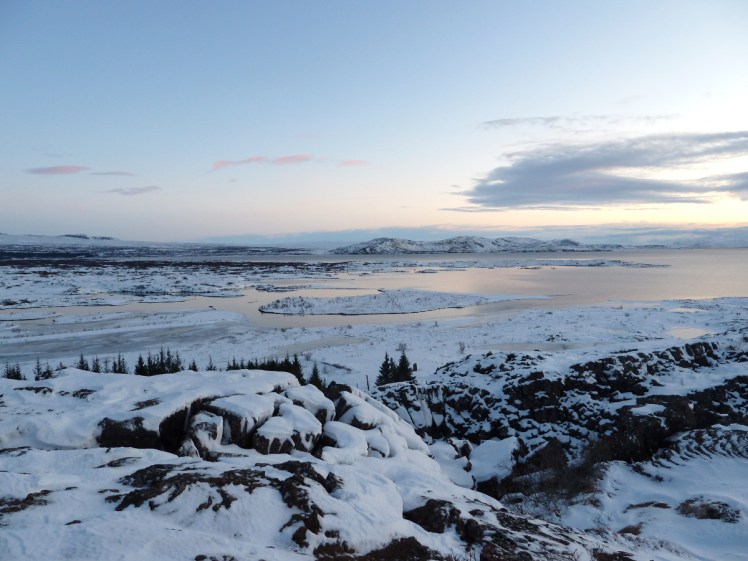
What is it? It’s a rift valley. If you park up by the visitor centre, those black cliffs you’re standing on are in fact the edges of the North American tectonic plate, the colossal slabs that make up the surface of the Earth. The edge of the Eurasian plate is somewhere across the plain, a few kilometres away, and what you’re looking at is a kind of geological no-mans-land, young lava rising up to fill the gap between the two plates. That’s how Iceland was formed – the plate boundary came to the surface and as they pulled apart, the land formed an island in the North Atlantic.

If you’re not interested in the geology, then perhaps you’d be interested in the history. The name Þingvellir means the Parliament Fields and this is where the young nation established its parliament in 930. Every July for nearly nine hundred years, the Icelandic people and its representatives met here to hear the law, dispense justice and, yes, have a big party. Now Parliament meets at a big grey building in central Reykjavik but once they assembled at and around the Law Rock. No one actually knows where this was – the rock with the flag and the benches is only a guess. It doesn’t help that the geology of this area has changed since those Viking days – an earthquake five hundred or so years ago moved the depth of the floor considerably.
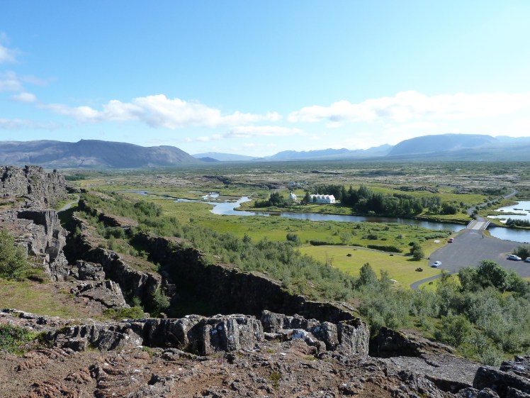
What’s more certain is the location of the camps. Up on the cliffs near the Öxarárfoss waterfall are the remains of some of those camps and it’s known that the early Parliamentarians diverted the Öxará river to better supply their Parliament with water.

If you’re not interested in history either, you might be interesting in the diving. Sure, the water’s cold, but it’s incredibly clear and you get to “swim between the continents”. There are plenty of companies doing diving trips, often with transfers from Reykjavik, ranging from snorkelling for beginners up to full drysuited scuba for people with the right qualifications. Dive.is run a two day course if you really want to get your drysuit qualification in Iceland, but you’ll need the PADI open water qualification already.
In terms of practicalities, there’s a visitor centre and toilets at the viewpoint car park, a small cafe at the main campsite down in the valley and more car parks below the cliffs. Back on the main road is a smaller car park and the Öxarárfoss path.
Other stops
The rest of your Golden Circle tour will depend on the whims of the driver and participants and tour guides so I’m going to rush through other potential stops.
Kerið

Kerið is a beautiful red-brown flooded explosion crater. If you want a nice easy first ever volcano, this is a great one. You can walk around the rim and enjoy views across the south west. Bjork once used this natural ampitheatre as a performance venue, singing on a a kind of barge floating in the lake. The downside of Kerið is that you do have to pay to park here and you have no idea how controversial that was when it first came along. These days you have to pay to park at Þingvellir and as it’s been more than two years since I’ve been to Iceland, I wouldn’t be surprised if there’s a machine at Geysir and Gullfoss by now. But Kerið is where the idea of paying for access to nature was born.
Skálholt
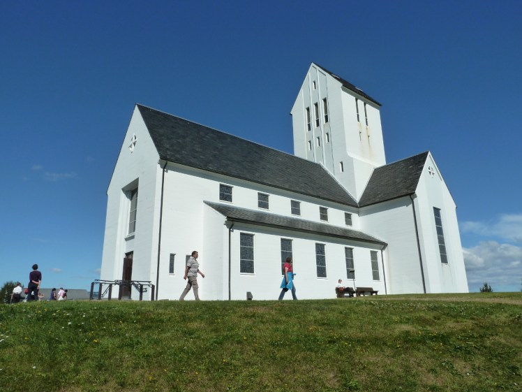
Skálholt is kind of like the Canterbury of Iceland. It’s got a cathedral (albeit a small one compared to Europe’s massive medieval edifices) and it’s a major religious site and education centre. Oh, and the site of the murder of the last Icelandic Catholic bishop, Jón Arason, who was beheaded as the country switched over to Lutheranism. Pop into the church and go down to the crypt to see the tomb of one of the former bishops.
Laugarvatn Fontana

I’ve talked about Fontana at length. It’s a geothermal spa built over hot vents in the lakeside and I love it. It’s one of Iceland’s younger spas, one of the smallest and quietest, and I think it’s great.
Faxafoss
This is a waterfall. The waterfall itself isn’t that exciting, in a country with almost as many waterfalls as people, but it has a salmon ladder up the side to enable fish to continue upstream despite the big drop so it’s worth five minutes as you’re passing by.
Efstidalur II

A farm, restaurant and ice cream shop. The restaurant has big windows at the back so if you have the stomach for it, you can sit and enjoy your steak while looking at the cows it used to be. Good ice cream. I’ve got an idea it does good greenhouse-grown local tomatoes but I saw good beef and excellent ice cream and assorted dairy-origin food rather than vegetables. If you’d rather not have lamb soup at Gullfoss and you haven’t brought a picnic and you’re looking for somewhere to stop on your Golden Circle day, this is just about the only place in Iceland this non-foodie would willingly and happily recommend.
Nesjavellir geothermal power station
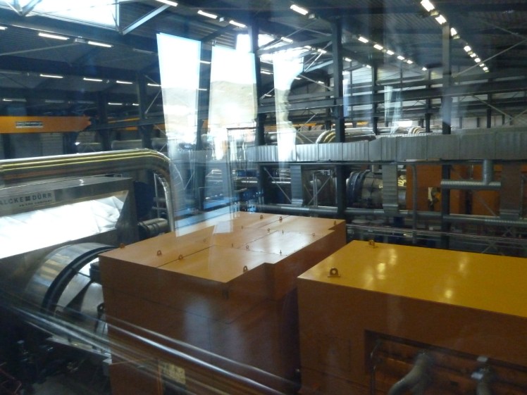
Iceland is famous for its geothermal power, although power stations like this one only supply around 30% of Iceland’s electricity; the rest coming from hydroelectric stations. If you’ve ever wondered what the inside of an geothermal power station looks like, Nesjavellir is open to the public, so you can come and find out. I believe the road down from Þingvellir can be difficult in the winter but if you’re there in the summer or you’re a tough driver, and you’re interested in renewable energy, it’s definitely worth popping in.
Of course, there are almost infinite places you could stop on your way around the Golden Circle. If there’s somewhere you’ve particularly enjoyed that I haven’t mentioned, leave me a comment and tell me about it for the next time I’m in Iceland.

3 thoughts on “The Icelandic Guidebook: The Golden Circle”