Welcome to part two of my Dartmoor weekend! Today we’re off on a different route, in the hope of getting another logbook walk. But today we’re setting off in two groups rather than splitting up. In theory, that’s because there are now eight of us and that’s a tiny bit big for a walking group. In practice, there’s been some Drama that I was oblivious to until half the group said they were going right now in their van because they didn’t want to walk with one of the group members and it’s nothing personal and it’s been lovely to meet you, have a good walk, etc.
So there are four of us. It’s Anne and I again, plus Jenny who was with the training group yesterday (she explained; it’s complicated; I didn’t entirely get it, but I don’t need to) and we’ve got Rob, who I didn’t mention was with us yesterday. His wife is in charge of this weekend and is with the training group. Rob is leisure walking, plus general dogsbody. If something needs pushing, pulling, eating or fetching, it’s Rob’s job. But we’re doing another route the other group planned, with another modification. This one was about six miles before we cut the bottom part off – it leaves the Open Access area and follows roads, so we’ve cut across the moorland above Buckland Beacon to avoid the roads.
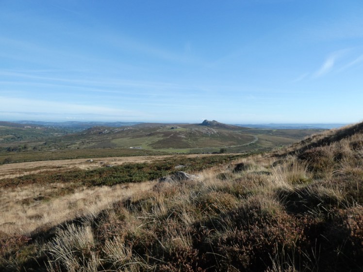
We started by driving five minutes up the road to Hemsworthy Gate, which is the little car park between Rippon Tor and Top Tor, which we crossed yesterday. Another ascent of Rippon Tor and the plan was to walk south-east towards the car park at Cold East Cross. Except we meandered on to the cairns on top of the tor, failed to find the massive and obvious track that leads down and had a type-2 fun adventure in the gorse, which very much tested the good nature I generally take out walking. Jenny, who’d assigned herself leader of the group, gave me her pole, which I accepted as it was just strapped to her bag and that helped with the uneven and invisible ground – I hate not knowing where my foot is going to land and I don’t like the rustling of long grass because I know there are no adders sunbathing here but you bet I’m going to worry about them anyway.

We detected a wall and decided at the very least, we could use it as a “handrail” to make our way to the correct place and that did work quite nicely, once we were out of knee-deep gorse and grass. Actually, on my paper map, that wall runs out before it reaches the next wall but on my OS app, it carries right on. From there, there was a pretty obvious path across Halshanger Common to the car park. Next, we were supposed to follow the orange road for a while before turning right onto a footpath across Buckland Common. The thing is, we avoid roads and there was a nice path that looked like it would run into the path we wanted. We took a chance. It did. But then we were supposed to come to the corner of a wall and turn towards another path which would lead us to a bridleway through Buckland in the Moor. We couldn’t find it. Anne broke out OS Locate again. Rob and Jenny walked among the ferns to look for it. Now I’ve downloaded my GPS track and put it on a map, I can see very clearly where we were meant to go but in real life, we totally failed to find it. But we did eventually get there by heading for Ruddycleave – if we came across a path going off to the left, then good. If we didn’t, we’d just be cutting a little more off the route than we intended and we’d still end up in the right place.

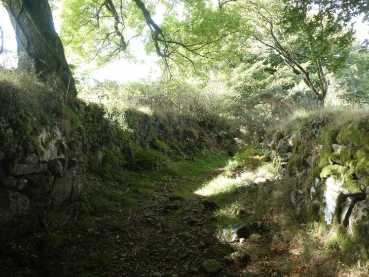
By pure luck, we did find the right path. It led us out of Open Access land and onto an ancient road, cobbled and between two immaculate ancient stone walls, so old that enormous old trees had grown into the walls. Very nice – but quite steeply downhill. I’d put the knee strap on that morning in anticipation of it acting up again and it did. Oh, it did. I sat down and tried to click it into place and assured my walking group that it only hurts downhill. According to the map, we’ll soon be going uphill again and then it’s mostly flat and uphill all the way back to the car. I can limp this bit, I’ll rest it at lunchtime and I can definitely make it to the end of the walk (spoiler alert: I did).
We followed a single-track country lane through Bowden and north towards Challamoor and then we were back on a bridleway that led across Pudsham Down, which is where we finally stopped for lunch, a good three-quarters of the way round. Then the plan was to walk two sides of an awkward square to come out at the foot of Pil Tor. Rob had pointed out a perfectly good foothpath that cuts across the short side of that square and I decided that I’d prefer to go that way and we’d rendezvous on top of the tor. Rob came with me, mostly because I think he thought I’m not really capable of getting there on my own.

We found our gap in the wall. We followed the wall on our right until it met a gate in another wall, which we were to keep on our left. A gate with a big red bar through its Open Access symbol and the word PRIVATE in big white letters. And to be fair, it isn’t Open land. So we had to go round after all. We wondered if we’d see Jenny and Anne, whether they’d see us, whether we’d catch up, whether they’d wonder where we were. We did see them, they did not see us, we did not catch up and by the time they were wondering where we were, we were very obviously traipsing up the side of the tor towards them. Yes, a difficult square. Halfway down the long side, it goes downhill very steeply and very roughly, which my knee did not enjoy. The rest of me didn’t particularly enjoy the subsequent walk upwards but at least it wasn’t causing physical damage. And so to Pil Tor! From here it’s a short walk to Top Tor, like yesterday and then a gentle amble downhill and back to the car!

We weren’t certain of the distance – we’d started with six point something miles, cut a bit off, accidentally added a bit on the side of Rippon Tor and all in all, Jenny didn’t want to drive back to Broadleas to discover it was 9.8km and she’d just missed out on a logbook walk, so she opted to walk back. It’s about 3km and we’d done it in reverse the day before, so it wasn’t too strenuous, and it would definitely take her over the required 10km. I drove back – well, it was my car, I had no other choice. Rob opted to go with Jenny and I took Anne.
My GPS says it was 9.63km, so Jenny was right to do the bit extra. On the other hand, as I said in my last post, a logbook walk is 10km or five hours and this was five hours and four minutes so I got a logbook walk without adding any extra.
Now we made a discovery. The other four hadn’t returned. Well, no, I said. They were leaving straight after their walk. But the centre was locked, they couldn’t have done. No, straight from the walk. They’d already packed.
It turns out no one else knew this. I assumed when I was told the sudden new arrangements, including that I had to squeeze four adults and our walking stuff into a Fiat Panda, that Anne at least knew that they were going straight home after their walk. Nope! I was the only one they’d told! That’s not only rude, to not say goodbye and thank you, but they were missing their share of the cleaning, they wouldn’t be getting their badges – oh, and someone would have sat potentially for a long time at Broadleas worrying about why they hadn’t got back! That’s a fairly major safety issue! I’d have told them much earlier if I’d realised no one else knew but I assumed they did! So for the “grown-ups”, that was a bit of a sour end to the weekend.
We had to clean the centre before we could go. That means everyone has to pitch in. I started wiping the tables and then Heather took that job over while I folded them and stacked them, with the help of Lucy from the training group and Louis, who’s just finished his tenure of region walking advisor. Then the training group had their debriefing so I hoovered all the rooms and the corridor, which I figured was more than enough cleaning, especially as there were ten or twelve other non-“grown-ups” to do the rest. I collected my badges and went – on your first walking weekend, you get the big green region walking triangle. For subsequent weekends, you get a tiny triangular badge with bootprints on it, which you can arrange to your liking, so they meander across your blanket. I got my triangle and my first bootprints in about 2016, but then I missed my second in Wales in November 2017 because Theresa forgot to bring the badges and my third right here in September 2019 because I was leaving early for a comedy show in Winchester. I’ve not forgotten, so I claimed those two and my newest one for this particular weekend and left the training group to do the bathrooms, sweep the main room’s floor and wash up everyone’s post-walk teacups.
And again, by the magic of Ordnance Survey, you can see my route here and follow it on a 3D Fly-through if you have an account! Wikiloc download here if you don’t have an OS Maps subscription and Google Maps here:
