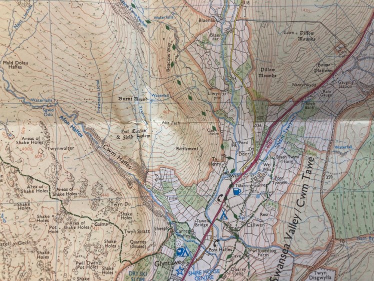
At the weekend I went to Wales for a Region level 3 walking weekend. In our part of the country, landscapes that fit the Remote criteria are a bit harder to get at than they might be for people who live further north, so when we do a level 3 walking weekend, it’s usually in the south-west corner of the Brecon Beacon National Park. That’s news to me because this is the area I caved in as a student. We never used the words “Brecon” or “Beacon”; we just called it South Wales, or the Black Mountains. Anyway, it’s the upper Swansea Valley, roughly centred on the showcaves at Dan-yr-Ogof and the Craig-y-Nos Country Park area. The South Wales Caving Club is on the mountain to the east of this valley, at the foot of Carreg Cadno and then there’s the Black Mountain on the west side. The Black Mountains, plural, is way up in the north-east of the national park.
We stayed this weekend in Ystradgynlais, which we were inclined to call “the village” but in fact, it’s the second largest town in Powys, which is itself the biggest county in Wales by some way. Ystradgynlais is also part of the “historic county” of Brecknockshire, which is Brecon County, which I presume means much the same as when people around here say “Poole is really a unitary authority but we all know it’s part of Dorset”. Anyway, it’s quite the thriving town, with plenty of places to eat and nowhere free to park! I know it as the hometown of Eve Myles from Torchwood and apparently the Archbishop of Canterbury Rowan Williams grew up there.
I arrived later than planned on Friday – the M4 was more or less at a standstill around Newport and then again between Port Talbot and Swansea so the satnav took charge of the detour required to get off the motorway and up to Ystradgynlais, only to find no one else in the group had had any trouble. We pulled the maps out on Friday night and I discovered everyone else had much more ambitious plans than me. I’d intended to walk with Theresa, who is currently taking things gently after major knee problems but she cancelled. You can’t go on a walking weekend planned at region level and then go off on your own so I got swept along with the plan to hike up to Fan Brycheiniog, which I already knew was going to be tougher than I like.
Saturday dawned extremely frosty and I wished I had some thicker hiking trousers or some thermals when we arrived in the lane where we were parking. Cross the road, go lawfully through the farm despite the warning on the gate and then…
“My map is folded so I can’t see this bit. Are we… are we going straight up?”
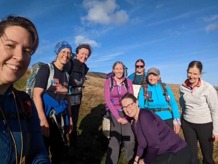
Yep! The route meanders a bit but basically yes, we were going straight up. Helen calculated 35 minutes – 15 for distance, 20 for altitude gain. I struggled. I hate going up hills. I knew on Dartmoor that Wales was going to be too tough for me; I knew it again as we planned the route and yet here I was. We were 30% behind target on that first section so the four fast and enthusiastic walkers sped on, after Val checked equipment, route and communication. That left four of us: Helen is a Mountain Leader and evidently the person nominally overseeing this adventure. Val is probably a Mountain Leader; very able and experienced but she’s also nearly 70. She can walk forever but she does it a bit more slowly nowadays. I think Gill has finished her level 2 qualification, which is the one I’m kind-of working towards. She’s slower than the first four but quicker than me and Val.
I led the next bit, under the impression it would be a long gentle pull up to the summit. And the first bit was. I set a perfectly respectable pace but then it began to climb. Fine. Gentler than earlier. But it wasn’t that gentle and it was endless. I knew it would be type 2 fun, the kind you enjoy in hindsight rather than at the time but wow, I really didn’t enjoy it. Why are we climbing a mountain? What’s the point? And why do people enjoy this?
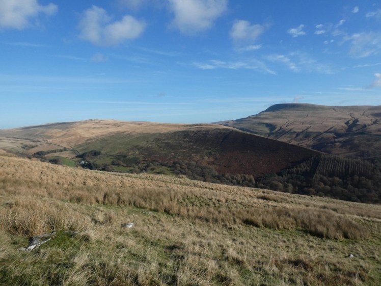
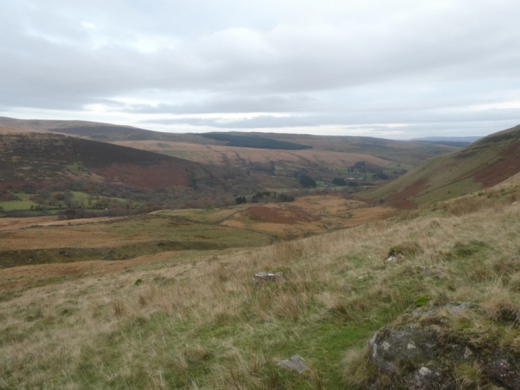
But worse was to come. The summit wasn’t the summit and the big mountain away over there was getting closer. I compared my map to the sheer drop on my left and the lake at the foot of it, considered the trig point on the map against the landscape and… we were going to climb “that big mountain over there”, weren’t we? Of course we were! The path dropped down a bit, then right up, up awkward stony steps while the wind began to howl. For a while we’d had sunshine, blue sky, the sinking feeling we should have brought sun cream. Now we had heavy clouds and winds and my baselayer/softshell combo wasn’t enough. And yet, sweating from climbing, I’d have overheated and collapsed if I’d added my fleece!
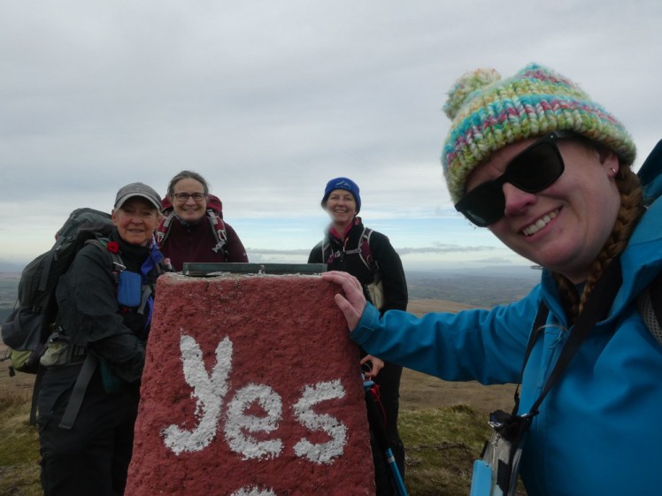
We made it to the trig point, three and a half hours in. Now we had the decision to cross high boggy ground and descend via an area of shakeholes or whether to descend the sharp ridge and follow the Brecon Way along the bottom of it. Thanks mostly to me, we were a bit behind and the former route, which had a good bit of up still in it, would take long enough that we’d definitely be pushing against the daylight. So, down the ridge.

There are steps, kind of. It’s more like a mix of random boulders embedded into the mountainside and a route hacked out by someone with a sledgehammer who’d never seen a sledgehammer before. It was slow and you can’t physically speed up or you’ll miss your footing and become a mountain rescue statistic. The men behind us declined to overtake. They complimented my “nice steady pace” and repeated that overtaking leads to broken legs. No, we’d all trudge down gently and slowly.
At the foot of the ridge, by the lake, we had lunch. Yep, a very late lunch. I’m not saying I would have climbed better if lunch had been earlier but I might have been less angry if I had some food in me. We’d had a brief elevenses stop earlier and what I’d learned was that however hot and sweaty I am when I sit down, I’ll be freezing by the time I stand up again, so I piled the layers on. We’d picked some rocks to sit on but they weren’t very comfortable. My bag doesn’t make my back ache but having it there all day followed by perching on a rock did. If I’d been able to lean back on something that would have been nice. Anyway, food and an entire flask of hot chocolate and then we had to go.
We walked back along the miniature ridge at the foot of the huge ridge, give or take a detour before we realised we weren’t lined up properly. I saw that ridge from the other side of the valley on Sunday – I’d had no idea how high we still were. After the descent of the ridge, it felt like we must be just a few feet above the valley but in fact, we were still pretty much on top of the mountain!

This was where my left knee started to hurt. It does that on weekends like this – left to my own devices, I rarely do walks long enough or steep enough to upset it. Dartmoor did it a mischief and now Wales did it again. It’s going downhill and it’s a common enough thing. I’ve googled it. Your kneecap is supposed to slide into a groove and sometimes it takes a moment to figure out where it’s meant to go and that’s the pain. There are exercises to teach the muscles to support the kneecap better so it doesn’t dither about where the groove is and I’m going to have to look into that. After Christmas, when I’ve got time to breathe and stretch. Anyway, walking along the bottom of the ridge was downhill enough for it to start to hurt but then we really had to dive down to the valley floor and that was when it really started to hurt. Combine that with sore feet from five or six hours of walking by this point, being too hot – I’d added the fleece at lunchtime and now I was sweaty, sore, in pain and it turns out I get really angry really easily at having to pick my way over rocks. See the return part of the Meradalir hike for more of the same!
I was vaguely surprised that I made it back to the car. I was even more surprised that despite me being slow, we were only about 25 minutes behind the other group. Admittedly, the other group had taken the route back via the sinkholes and had had a spot of bother with some river crossings, whereas we’d taken the shorter route but to only be 25 minutes behind them wasn’t so bad.
It’s in my logbook. It’s a level 3 walk – I’d had my doubts about that at the time but I think it’s pretty firmly level 3, with the section climbing down to the lake classified as “if you brought girls up here, this isn’t level 3 territory, this is ML”, which means you’d need the Mountain Leader qualification rather than merely Girlguiding’s level 3 Remote walking qualification. As you can possibly imagine, there are few enough level 3 candidates that they run them alongside ML trainings because if you’re going so far as to get your level 3, you might as well do the handful of things to take it up to the nationally recognised high-level qualification. It also counts as a Quality Mountain Day: whereas Girlguiding counts “logbook walks”, Mountain Training logs Quality Mountain Days for its various qualifications. I suppose my Wales 2016 walks probably count as QMDs but no one named them as such at the time, so I’m regarding this as my first ever logbook QMD.
You can download the GPS track from my Wikiloc here – please bear in mind this is quite high, quite cold and quite hard work. Go prepared.
