Dartmoor is 70! Well, it will be the day after tomorrow, October 30th. And by 70, I mean it’s 70 years since it was designated England and Wales’ fourth National Park. The other three weren’t far ahead, all designated in 1951 too. The Peak District came first, in April, followed by the Lake District in May. Snowdonia beat it by less than two weeks, on 18th October and then on 30th October 1951 came Dartmoor, the newest National Park.
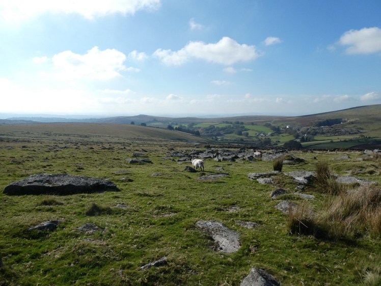
Of course, Dartmoor itself is millions of years old. That granite was created about 280 million years ago, according to the official Dartmoor A Level Geology & Geography factsheet. Granite, if you remember your schooldays, is an igneous rock which means it’s formed from lava, which means Dartmoor is technically a volcanic landscape. It’s also a wild and desolate landscape – one of the few places in England, or southern England anyway, that you can truly call a wilderness. It’s the National Park I know best, although the New Forest is closer to where I live. But I don’t do Level 2 walking in the New Forest. I don’t think it’s what’s considered “Open” countryside, although I don’t really know – the definitions are a tedious ongoing argument on any walking weekend.
My plan for this post was to tell you about the long and arduous hike I did across Dartmoor on my recent Cornwall/Devon holiday to celebrate its birthday. But on the day itself, I had a series of catastrophes featuring a fresh tank of petrol evaporating before my very eyes (yes, really) and the hell of parking in Princetown and then losing my compass, so the story is a little shorter.

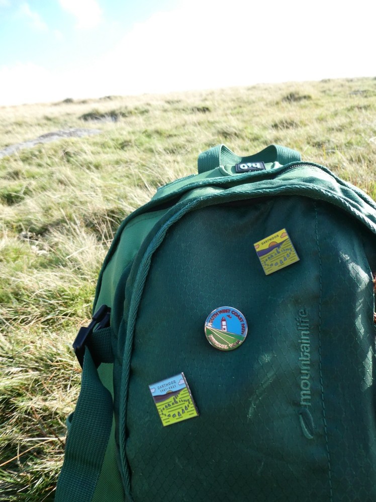
I had two routecards written out with walks on them. One starts with a two-hour uphill climb and covers just over 13km. The other feels less climby yet somehow has double the ascent but is only just over 10km. But I wanted to pop into one of the visitor centres because I wanted the Adventure Pins 70th anniversary pin and I was pretty confident they all stocked it. Adventure Pins have been promoting the Peak District 70 pin all year but I only know the Dartmoor one exists because it popped up once on their Insta story. The Lake District and Snowdonia haven’t even had that. Do they exist? The Peak District one features on their grid and stories and is available in the shop. Also, the Peak District one is a special design. The Dartmoor one is just the normal one recoloured and with the dates on. I’m not huge on pins – I don’t want to weigh myself down with too much unnecessary metal on my bag so I have their Dartmoor and National Trails’ South West Coast Path and that’s quite enough. I admit, there are some others I’d like but they’re obscure areas or trails and the pins simply don’t exist, so that’s fine.
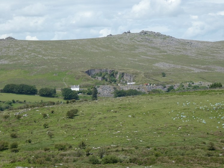
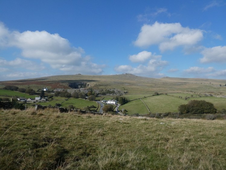
In pursuit of the 70th anniversary pin, I decided that the Princetown visitor centre was best. It was closest to my home for the weekend and I decided rather than doing a long slog with a lot of hill, I’d walk out a couple of miles from the town and investigate the Merrivale Bronze Age remains. It wouldn’t be a long walk or a particularly arduous one but it would be interesting. And then I arrived and I couldn’t park in Princetown because I live in 2021 and I don’t carry coins around. No card, phone or app option to pay and no way to get cash in Princetown. What, as Jayne would say, is that all about? I shot into the visitor centre and bought the precious pin and begged for help with acquiring coins but to no avail. So I had no choice but to drive out of town, with my too-rapidly diminishing petrol and I parked just up the road from the remains.
In a way, it’s good for me to sometimes be forcibly reminded that Dartmoor is worth spending time on without putting myself through a long and tough walk, without adding a new logbook walk to my collection. That I don’t have to walk 10+km for it to count as “spending time enjoying Dartmoor”. Dartmoor is many things to many people and I need to stop seeing it as the place I get my level 2 logbook walks. It can also be the place I walk the dog – well, it couldn’t because I don’t have a dog and there are many places a lot more convenient to my home for dogwalking if I did have one. It can be the place where I picnic in front of a nice view. It can be the place I stroll gently to appreciate the solitude and quiet. Apparently it can be the place I try whitewater kayaking. Horseriding. Ten Tors. There’s so much to do on and with Dartmoor and while I do need my twenty logbook walks for my qualification, I also need to learn to appreciate Dartmoor in different ways.
I may have mentioned in my Roadford Lake post that I picked up a book called Ancient Dartmoor. It’s not actually particularly helpful. It talks about how there were people living on the moor in Bronze Age times and how there are things left behind – villages, pounds, stone rows, standing stones and so on – and there are helpful grid references for finding some of them. It’s quite interesting in that it gives some history and some information about how archaeology works (and doesn’t work). But it’s very vague on what anything specific actually is. It says that there’s stuff at Merrivale, quite easily accessible and still quite obvious. But what is it? The remains of a village and a ceremonial stone row with remains of a cairn and cist in the middle of the stone row and none of that is actually as useful as it sounds. What do you mean “ceremonial”? You mean “it must have had some purpose that wasn’t housing but we don’t know what it is”.
I knew where Merrivale is. I’d walked very close to it on my Princetown Railway walk earlier in the year but not bothered to make the short detour to visit any of it. I’d be doing virtually nothing but visiting it today, since Princetown’s parking had put a stop to my plans to walk across the moor to it. But that’s ok.
So I parked and I walked. It’s about half a kilometre, maybe a bit less, from the car park and there was a man on his knees among the stones, in exactly the right place that I couldn’t take a photo along their lengths. More mysteriously, he had several pairs of scissors and a pair of secateurs and was hand-trimming the grass around the stones. This is moorland. This is wilderness. This may be a ten minute walk from one of the biggest roads on the moor but it’s still moorland. There are cows and sheep grazing just a few yards away. You don’t need to cut the grass. I daresay there is some management of the landscape but I don’t think it involves much mowing. It just flabbergasted me. Do you not have anything better to do with your day than hand-cut grass on the moor? I’m willing to be told that there’s some sort of preservation or conservation thing going on here but these stones predate Jesus. These stones are two to four thousand years old. Pretty sure they’ve managed most of that time without some well-meaning person with nothing better to do trimming the grass around them.

I left him behind and walked along the row. The row is made up of two parallel lines of stones four or six feet apart. Twenty or so yards away is a second stone row, not quite so big or obvious and not so long. Halfway along the bigger one is a small low stone circle with a rough hole in the middle. I think this is a cairn and cist – “cist” being pronounced a bit like “kissed”, not “sist”. Basically, it’s a coffin, to the best of my understanding. It’s a stone burial chest buried inside a circle of stones, the cairn. A lot of them have been looted, robbed or dug up for educational purposes over the last few thousand years so it’s easy to mistake a cairn for a stone circle or the remains of a house, although most of them are far too small for a house. Still, archaeology is an imprecise art and archaeologists misinterpret things all the time.
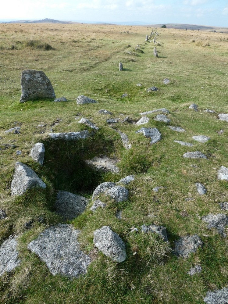
At the far end of the stone row are two menhirs, or blocking stones – which I gather means that the standing stones at the end of a row are taller than the rest. There are some on Dartmoor that are enormous. The Merrivale stone row is pretty small stones and the menhirs are also pretty small. From here, I looked across at a tor in a valley ahead and another on a hill and decided to use my map and compass to find out which they were. At which point I discovered the compass I’d attached to my left backpack gear loop was missing. I retraced my footsteps and finally found it next to my car, so that was the best part of 2km walked for absolutely nothing.

I walked back and discovered that the tor in the valley is Vixen Tor, which lies in private farmland. The map seemed to suggest at the end of this field was a boundary so I investigated. Yes, a tall stone wall that went all the way down to the road. Well, at least both my map and my reading of the map were accurate. Lots of field boundaries, even today, are exactly the same boundaries that were used back in the Bronze Age, by the way. Not necessarily the same stones or walls but in the same place, on the same lines. No one at any point over the last few thousand years has seen much point in moving the outline of a field so it’s remained where it was placed up to four thousand years ago. That’s incredible. No idea if it’s applicable to this particular boundary.
By now it was about half past one. It had been a long and stressful day and I could feel it so I found a rock and sat down to eat my lunch. I’m not quick to match food and food intake but a friend of mine had been talking about it recently and I could hear his voice talking about “pouring a bag of M&Ms down their throat” when people start to get fractious so I stopped to eat. I’m not sure it had quite the magic effect it should have but it had to have done some good.
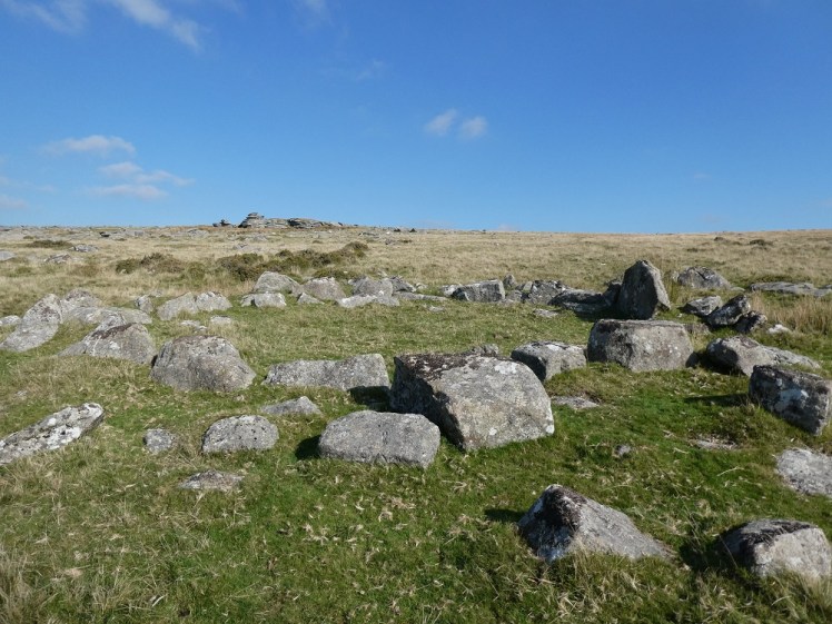
From there I walked down towards the road and the small car park. My map said this area is all settlement but on this side of the road, it’s impossible to tell. It’s all just scattered rocks. Maybe it’s the remains of a village. Maybe it’s just a big load of eroded granite. The other side of the road was clearer, though. There’s a small tor, marked on my map only as “settlement” which I’m pretty sure it’s not but there are also several very clear circles of small house size among the boulder field. It seems like a pretty substantial place and reasonably well-identifiable as indeed a settlement. I climbed the tor, I took photos of the circles and I walked back across to the car.
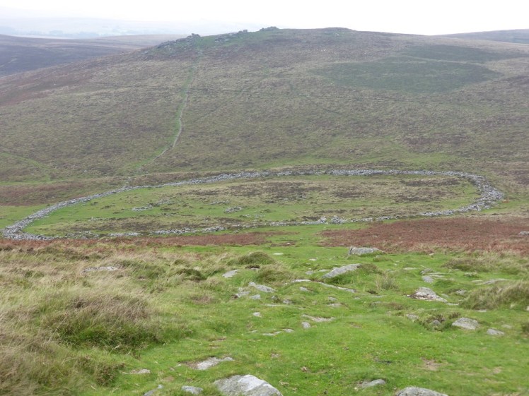
If you’re interested in ancient remains, another easy and obvious one is Grimspound. It’s a pound settlement, a huge circular enclosure with the settlement inside. Grimspound is a pretty big one and its outer wall, which is a good few feet thick, is pretty well intact. It’s just a little way south of Hookney Tor and about a 400m walk from a lay-by on a tiny road between the B3212 (about halfway between Moretonhampstead and Postbridge) and the unnumbered road between Widecombe-in-the-Moor and Ponsworthy, although it’s a lot closer to the B3212. I’ve visited it a couple of times on my 10+km hikes – once on a walk I don’t have the details of but which started in Widecombe and took in Hameldown Beacon, and once on… well, it was probably a pretty similar walk, heading north from Widecombe and going via Hameldown Tor, Grimspound, Hookney Tor, Challacombe Farm and back to Hameldown. I blogged about it here – it’s the walk where I wore the wrong insoles and gave myself horrendous blisters. Also, it poured with rain. It’s a pretty good walk, especially if you’re more interested in ancient ruins than the state of your own feet.
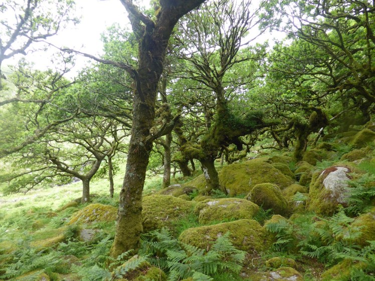
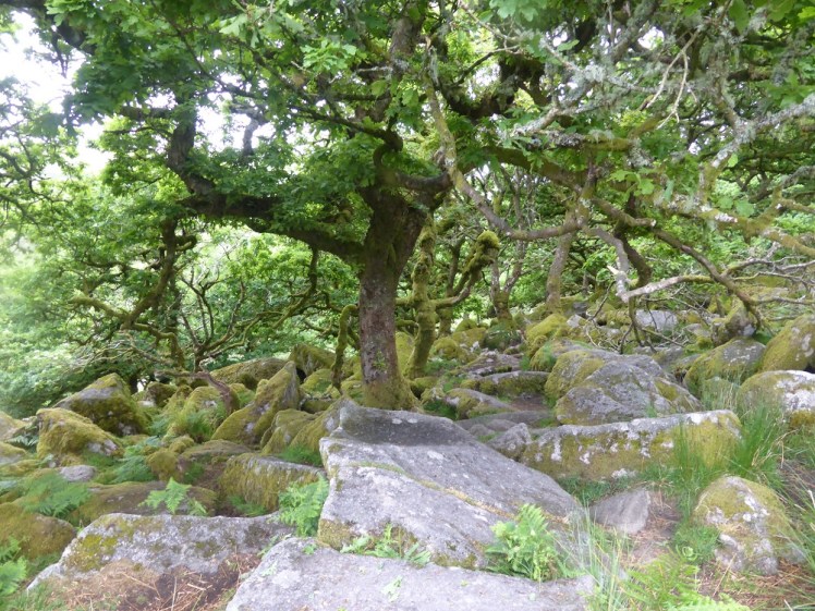
Finally, we can’t talk about cool stuff on Dartmoor without a shout-out to Wistman’s Wood. Now, I don’t necessarily want to send you off to visit it – it’s one of the better-known places on Dartmoor and the authorities have been trying to close it off or at least direct people around it for a while because sheer numbers of visitors are damaging it. It’s an ancient woodland, one of three high-altitude oakwoods in the entire country. Yes, it is indeed mostly oak but there are also some other things mixed in and it’s all sprouting out of boulders. It’s very pretty, it’s a nature reserve and it’s also a Site of Special Scientific Interest. From my point of view, an important thing to consider is that a lot of adders live there. I’m unreasonably scared of snakes. It was fine the first time my walk passed through the woods because I didn’t know about the snakes but now I do and that alone is a good enough reason to skirt around or divert the walk. Absolutely worth seeing but better for the wood itself and for avoiding bites to see from a bit of a distance.
Here’s the thing. As I said at the start, there’s so much more to Dartmoor than merely putting miles under your feet so you can earn a logbook walk. Take your time to investigate the history, enjoy the wildlife, moo at the cows and otherwise enjoy England’s greatest wilderness. And I think if I do that, I’ll be more inclined to do the big walks again, if I know I’m mixing them up with being slower, gentler and more appreciative. That’s not a bad birthday present from Dartmoor. Happy 70th. You look every day of those seventy years, and a few thousand more.
