I went to Dartmoor last weekend.
I’d expected half the country to be joining me on my drive westwards on a hot September Friday but it seemed there was more traffic heading east and definitely a lot more caravans. Had Devon and Cornwall kicked out all the holidaymakers? I’d set off reasonably early in the hope of avoiding the worst of the traffic but other than the usual bottlenecks, it was a fairly easy drive down to my campsite on the eastern edge of Dartmoor. Well, the last three miles were ridiculously difficult, getting from the Devon Expressway up to the village on the side of the hill. My directions were “Don’t use the satnav. Use this postcode and when you get there, use this postcode and then follow these directions”. That’s very difficult for one person using their phone for satnav and directions. I went the wrong way twice and those roads are barely any wider than my car.
But I got there. I’d decided to go for a bare-bones site because I’m still very wary of other people and I thought a plain field might be quieter than the touring site I wished I’d booked while I was driving around yelling in lost frustration. It was quiet enough but busier than I’d expected and a lot steeper. No two ways about it; my tent sloped violently downhill and since sleeping bags and mats are both shiny, I spent a lot of the nights hauling my bedding back up the hill.

I planned to do some walking. In 2014, I did a level 2 walking training weekend at Haytor and I’ve been back a couple of times for leisure walking weekends which run alongside the training. Obviously, it wasn’t happening this year but I decided that camping and hiking across Dartmoor were about as COVID-friendly as it gets and I’d go and do it alone. It would give me a logbook walk and it would also be the first time I’ve really tested my navigation abilities. I was pretty confident in them – the leisure walking is led, or at least guided, by a group of long-term Mountain Leaders and although we’re only there for leisure and logbook walks, they make us stop regularly for unofficial navigation lessons and I learned more from those weekends than I did from the training one.
My Saturday plan was my logbook walk. For context, that means it has to be in Open country (non-mountainous countryside with reliable paths or linear features etc), 10km or five hours. There are a few more details – weather, locations, group status – but the bit I needed to worry about was the length. I’d picked a walk from my Cicerone Dartmoor guidebook but I’d amended it slightly. I planned to start at Saddle Tor, walk across to Haytor and then across to Smallacombe Rocks. From there, downhill to cross Becka Brook and back up to Hound Tor and then round via the foot of Top Tor. The book wanted me to detour from Haytor Quarry to Holwell Tor and it also wanted me to climb Top Tor. I cut both of those out and then I route-carded it.
I don’t normally do a route card, not even for the sake of my logbook, but the guidebook wittered on for nine pages, talking about the history and the scenery. That’s interesting, but it makes figuring out the route a bit difficult. The little map wasn’t helpful either. It uses the 1:50 000 map and the orange line drawn over it is so wide that it’s no use. So I got out a blank route card and a calculator and I went through those nine pages and made a route card. And then I broke out Excel and built an automatic calculating spreadsheet. I’m so proud of it.
If you want to do this walk as well, you can download my interactive self-calculating route card here or download the GPS track from my Wikiloc here.
You can choose your own walking speed and choose your start time (drop-down selections in the yellow boxes) and it calculates everything for you or you can delete everything and use it for your own walks. Well, it doesn’t calculate everything. You need to measure your distances and your contours but then it works out the time it’ll take and what time you’ll reach the end of each leg, plus the same for all the totals. We use 3km/h, which we call Group, on the walking weekends and I didn’t imagine I’d suddenly become a speed-walker just because I was on my own. And I used my handwritten version of the route card which didn’t have a start time or a definite lunch stop, so I hadn’t filled in the “what time do I finish this leg?” column in. I was very impressed when I got home and filled in the actual start time and my lunch stop and discovered that it calculated for me to get back to the car within five minutes of the actual real time.
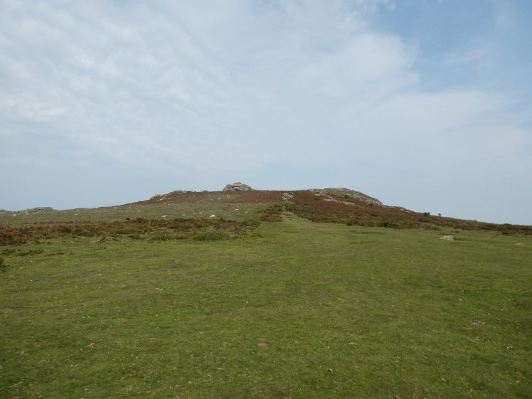
Now… I messed up right at the beginning. I walked to the top of Saddle Tor, in biting winds and surprisingly hot sun, and looked across to Haytor. It wasn’t there. Haytor is not the kind of tor you can just miss. It’s very prominent, very rocky, very noticeable. It can’t just be missing. And the truth dawned on me. I sat down on the east side, unfolded my map and compared it with the car parks below. Yeah, I’d done something spectacularly stupid. I was already on top of Haytor. I’d gone round the bend, Haytor had vanished out of sight for ten seconds and when it reappeared, I’d decided it was Saddle Tor. This was something else I had to adjust my route card for.
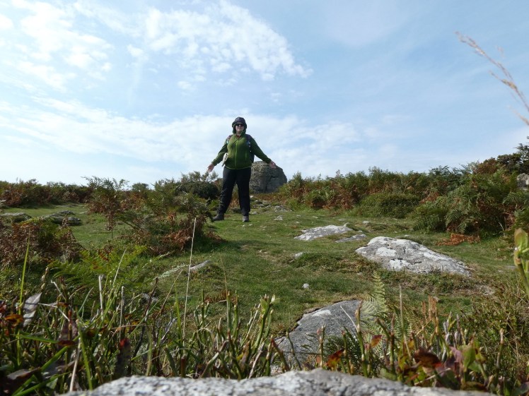
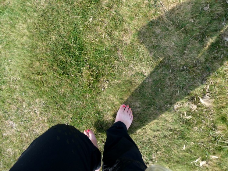
From here, I walked down to Haytor Quarry. I had no real need for my map now I knew where I was. All the paths were laid out in front of me. It’s normally drizzly, at best, when I’m on Dartmoor in late September but this was a beautiful clear day and there was very little need for navigation. I merely walked down the hillside to the quarries, spend a while taking timer selfies and then turned to Smallacombe Rocks. I used my compass to check the rocks I was looking at were the rocks I was supposed to be walking to and then set off. Thirty seconds later, something occurred to me. I hear a lot about barefoot walking but I’ve not really done it. This seemed the perfect opportunity. I was following part of the old granite tramway and part of the wide grassy paths. It was all smooth and soft and where there were rocks, they were smooth slabs. So I took off my boots and put my soft unaccustomed feet directly on Dartmoor.

It was ok. The main issue was sheep deposits. The ground itself was pretty good underfoot. I’d love to tell you how I connected with the Earth or how I felt something other than grass on bare skin but… I just felt grass on bare skin. I’d been cheerfully walking around my tent getting packed up barefooted because I was too lazy to put my sandals on and it just felt like that. Except when I’m pottering around my tent, I don’t get questions from concerned passers-by who think there’s a possibility that I’m heading deeper onto the moor when my feet hurt so badly I can’t even wear boots.

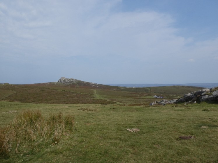
I put the boots back on at Smallacombe Rocks. From here, I’d be heading sharply downhill on some quite rocky ground. I could see rocks opposite. It would take a little while to get right down into the steep valley and even longer to climb back up the other side – why had I picked this route?! – and then I’d be at the rocks. I wasn’t sure whether I was seeing Greator Rocks or whether I was seeing Hound Tor itself but I was clearly meant to go there and once I was there, I could be more sure of which one I was at.
Downhill, down the narrow steep track, to where it met the public bridleway. Into the woods. This was where I doubted my route for the first time. It’s not necessarily obvious where to go and although there had been people in front of me earlier, they’d vanished now. But then Becka Brook appeared in front of me, with a stone bridge across it. I recognised it from a long-ago walking weekend. From here, I had to climb sharply uphill and there was a gate at the top of the first bit of hill. In hindsight, I know realise that was the point where I briefly left the open access land. Most of the moors are access land but there are patches and “bays” missing from it. However, I was on the public bridleway which would lead back to the access land at Greator, so it was fine. I’d measured on my route card that I’d be crossing ten contour lines within a single kilometre here, so this was due to be a long slow crawl and I was very glad to get to the second gate and see a mass of rock in front of me.


I was reasonably confident this was Hound Tor, not Greator. I was reasonably confident that the rocks trying to stick out of the vegetation right next to me was Greator. So I untied my compass and took a bearing from my spot up to the suspected Hound Tor and then compared that bearing to where I thought I was on the map. It matched! I was at Greator ahead of schedule!

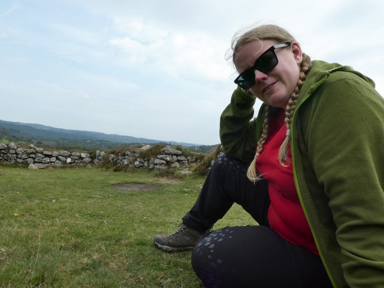
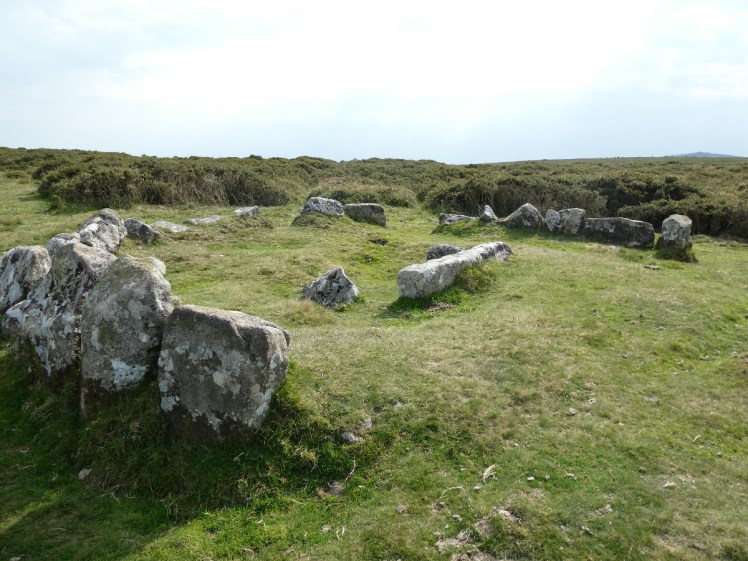
I wanted lunch fairly soon. It was noon and I’d done quite a bit of walking and I’d had an idea of stopping for lunch at Greator. But looking at the reality, I decided I’d walk on for five or ten minutes and sit down in the ruined village at the foot of Hound Tor. That was a good decision – there was a better view from there and I could sit in one of the buildings and take some shelter from the wind. There are a lot of Bronze Age ruins on Dartmoor – many’s the time I’ve stopped at Grimspound, just a few miles west, a huge Bronze Age circular ruin on the hillside. I assumed this thing was of a similar age and was a little astonished to find it was marked on the map as “ruined medieval village”. This place dates from around the middle of the thirteenth century. It seems to be eleven buildings, mostly “Dartmoor longhouses” which had people living at one end and animals living at the other. To my uneducated eye, you can tell this isn’t Bronze Age or otherwise pre-Roman, because it’s rectangular. They seem to have gone for circles before that. Anyway, it made a great lunch spot.

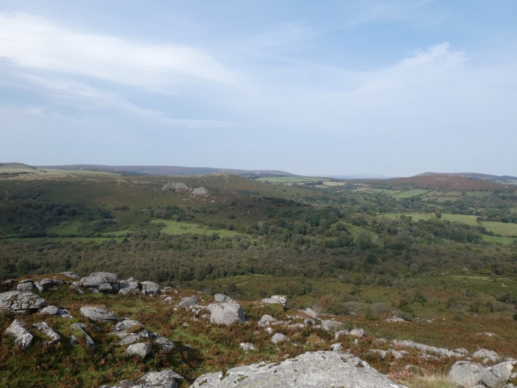
After lunch I had to climb up to Hound Tor. It wasn’t quite as bad as the pull up from the brook but it was still pretty steep and I was very pleased to reach the top and sit down for five or ten minutes to enjoy the view I’d earned. There were people bouldering on here and a young couple with two young kids who were enjoying scrambling over the rock. Hound Tor isn’t quite as prominent as Haytor – which was infuriatingly visible and close considering it had been two or three hours by now – but it’s a pretty noticeable and well-known tor. You might know it as the one Sherlock stood melodramatically on with his coat flapping in the Dartmoor breeze. I’m not 100% convinced – I don’t think the background in the show quite matches what I saw but then I don’t know Hound Tor all that well.


Now I had to return to the road. I took a bearing and headed off across the field, pausing at the cairn & cist. It’s a neolithic burial monument and although the remaining stones make it more interesting than a barrow, which is mostly just a hump, it’s still a bit underwhelming. Still, it’s a landmark, if you need one between the big noticeable tor and the road. I knew I had 2.4km of road to walk along to get to Top Tor but I hadn’t really realised how much of it I’d spend literally walking along the road. It’s very that easy to walk on the moorland alongside on either side, although I added a bit of mileage trying to figure it out.


I soon realised I’d made a good call on cutting out Top Tor. It’s actually quite a bit lower than Haytor and it’s only four metres higher than Saddle Tor but it looked huge. A gentle-sided mountain. From the road junction where I’d be starting the climb, it’s only four contour lines and the junction is virtually on the first one, and it’s only three hundred metres. On paper, it was utter laziness to skip it. But in reality, I’d just walked for three or four hours and I still had more than 3km to get back to the car, and Saddle Tor. I could have skipped Saddle Tor too. Strictly speaking, getting from Hemsworthy Gate to the Haytor car park didn’t involve climbing a tor just off to the north of the road. But my original route had started at the top of Saddle Tor and even if my route had adjusted itself slightly, I needed to climb the tor. I should have started the day at the top and I was absolutely going to finish it up there. And I did.

The guidebook’s route had been 12.5km. By the time I’d modified it, it had been 8.9km. Adjusting for what I actually walked, with the start at Haytor, worked out at 9km. But when I plugged in my GPS on Sunday afternoon and downloaded the data, I’d walked 10.13km, which was good because I’d only been out for four and a half hours. Remember the criteria for a logbook walk? 10km or five hours. I had a logbook walk!
So that was my Saturday walk. There’s more to come but this is already too long so part two will be coming later, as well as a gear review.

3 thoughts on “Dartmoor: a warm windy walking weekend (part 1)”