If you’re looking for an easy hike in Iceland with something worth seeing at the end, you’re spoiled for choice. A popular one is Stuðlagil, which is about a 6km round trip from the lower, eastern car park and is pretty much flat and paved all the way. But today we’re going to a more vertical hike, from Skaftafell campsite to Svartifoss, the Black Falls.
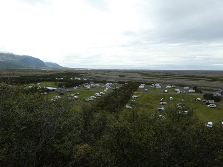
Skaftafell is an activity centre and former national park at the foot of Vatnajökull in east Iceland. Skaftafell now comes under the umbrella of the Vatnajökull National Park. You can come here to meet tours out to glaciers or Jökulsárlón, the glacier lagoon. I did a spectacular day trip out here in 2012, which ran for about 17 hours from Reykjavik where we did a glacier hike and then a boat trip on the lagoon, or you can just hike by yourself or, if you’re less pressed for time, you can camp here. It’s one of the biggest campsites in Iceland and it sits between three glacial tongues. When I’m camping, I quite often like to do the gentle stroll down to Skaftafellsjökull in the evening but this time I decided to hike up to Svartifoss. The board outside the information centre says it’s about an hour and a half’s round trip and I was almost disappointed to discover that they’re absolutely right about that.
The path starts from the middle of the campsite. Follow the path up the back of the campsite, not the big road where the tent campers leave their vehicles but the one that winds through the back of the camping fields. At the start of the third field, on your right, is a path leading upwards. You’re very unlikely to get it wrong at this stage but if you look to your left, a path lined with trees leads to a toilet/shower/service building so if you can see that, you know you’re in the right place.
According to my Strava data, the hike from the campsite right up to the platform under the waterfall and back – I was camped right at the foot of the path – is 3.91km, it took me an hour and 27 minutes with an elevation gain of 173m. Now, I’m really bad at climbing hills. I can swim for probably a lot longer than you, I’m a reasonably strong kayaker and canoeist as amateurs go, I can trudge onwards on the flat for 14km pretty comfortably and 20km a little less comfortably but the one thing I’m really bad at is walking uphill. I huff and puff and stop to take photos of the view as an excuse to just stop, even though I’m on my own and don’t need to make excuses. I get overtaken by old ladies and small children. Have done for decades. But the information reckons an hour and a half and if I can do it in that time, I think that’s pretty good evidence that this isn’t an overly-strenuous hike.
It’s almost all paved, either with gravel path or with matting meant to protect the gravel path. There are one or two places where you’ll need to look at the signs to see where you’re going but as a general rule of thumb, you’re either continuing on or you’re heading to the right. There’s one point where you have the option to turn left but that’s a longer and harder hike. You don’t need a map and compass for this one, and while I’m at it, you don’t need to equip yourself for an expedition. Now, I went on a dry day (well, it was in the morning!) in the height of summer. I wore hiking sandals, hiking trousers rolled up halfway up my calves, a t-shirt with a flannel shirt that I never put on tied around my waist just in case and all I carried, in my pockets, was my phone, my camera and my van key. Use your common sense. If there’s any chance of rain, take waterproofs. If you need medication, take it with you. If you’re going to need to drink huge amounts of water over less than 4km, carry huge amounts of water.

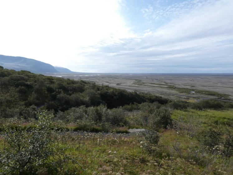
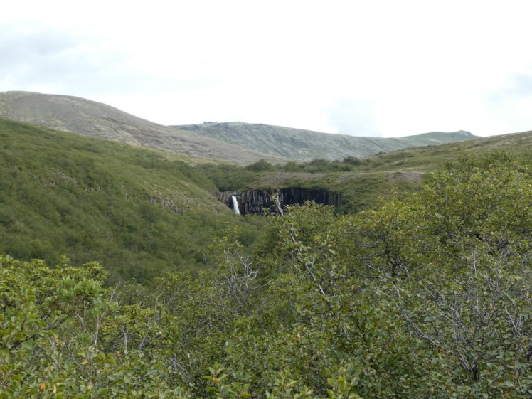
At first you’re just walking up a path with scrubby trees and vegetation on each side. The campsite drops away surprisingly quickly and every gap in the vegetation gives you a better view over it until it basically vanishes underneath the mountain and by the first viewpoint, you find you’re looking out over the sandur, the expanse of grey floodplain scraped out by glacial floods over the centuries, towards the open sea. It’s quite a bleak view in a spectacular way. You’ll also see a couple of waterfalls on your way up, none of them at particularly good angles.
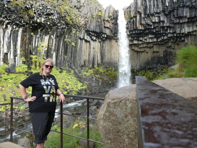
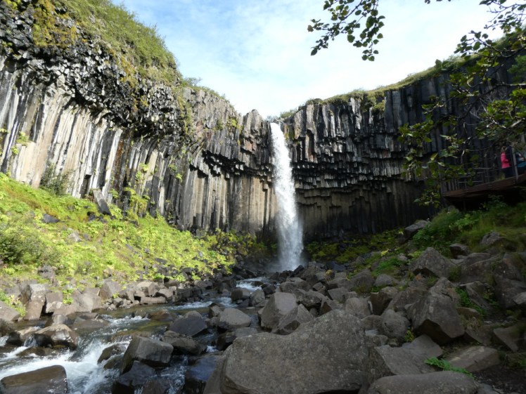
Then the path takes a noticeable turn away from the view and into woodland and if you look carefully, you’ll notice a little black “bite” out of the woods, which, as you get closer, reveals itself as the little basalt amphitheatre with the waterfall tumbling down it. The good path runs out at a big clearing and from here on, you’ll be scrambling over a rocky and partly muddy path sharply downhill. At the bottom, the path divides. A different hike continues over the wooden bridge but the bridge also provides a good viewpoint for Svartifoss so do stop off here. The actual Svartifoss viewpoint is up another slightly awkward scramble to a platform. The last I was up here, there was no platform and I waded out into the cold water – wearing sandals back then too – and had my photo taken there. Now, although there’s nothing physically stopping you, the presence of the platform sticking out a little way over the river discourages it.
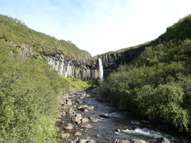
Although lots of people had overtaken me as I’d huffed and puffed my way up the hill, I somehow had the viewing platform to myself for a couple of minutes, so I set up my camera on the side of it and took some timer selfies before settling down to photograph Svartifoss from every angle when more people arrived. It’s called the Black Falls because the basalt columns forming a miniature cliff are pretty much black. Nothing that a good pressure wash probably couldn’t clean off, like the sandstone buildings in central London. Up closer, it looks less like a bite out of the landscape and more like someone’s arranged several sets of piano keys around the clearing, with the white waterfall falling over them. Get a bit of sun on them at the right angle and the green vegetation turns bright enough to add a bit of colour to the scene and perhaps, if you’re not there at 9.50 in the morning, you might get sunshine on the river as well, adding blue to it all.
According to the timestamps on my photos, I was there for just ten minutes, which seems absurdly short, but I was against the clock. I’d left the campsite just after 9am, with no idea how long the hike would take (I got the information from the board at the information centre when I got back) and knowing that if I took long enough that I overstayed my camping checkout time, I’d be charged for a second night, so although I lingered long enough to take some ludicrous selfies and lots of photos, I didn’t have enough time to hang around for half the morning.
As usual, the walk back was much quicker – and easier – than the walk out. I paused on the awkward climb back up to the gravel clearing from the waterfall to watch a wren have a dust bath right in front of me but other than that, it was all downhill and I have no major trouble with that. I took long enough to take several photos with my film camera from several angles on the way back – I’m not an expert on elderly SLRs so I had to manually light metre every photo with an app on my phone, only to discover a couple of weeks later that I hadn’t loaded that roll correctly and had zero photos from the east of Iceland onwards – so that took a bit of time.
On the way back, I had enough breath to look at the people starting to come up, definitely more than had overtaken me on my own way up. I noticed that a lot of them were loaded down as if they were planning a multi-day hike, that almost everyone had hiking boots on, that many of the boots looked brand new and that the summer’s colour for expensive women’s hiking trousers was a kind of reddish plum. I looked like exactly the sort of casual idiot who’s utterly unprepared and needs to be rescued. But my sandals are good hiking shoes – a tour guide who berated me for them back in 2012 was forced to say grudgingly to me at the end of the day “you have seal feet” after my sandals had done everything everyone else’s boots had done and a lot more – and it was a warm, dry morning and it’s a short, easy hike.
So, it was less than 4km and it took an hour and a half including lots of picture time. If you’re at Skaftafell or passing Skaftafell and you fancy a short, sharp but spectacular hike, this is a good one and worth your time. Make sure you pay for parking before you set off, or make sure you have enough time left on your camping payment.
