The reason I had two whole weeks in Iceland in a campervan was that I had A Birthday while I was there. The capitals signify the significance, I’m still not comfortable with saying the actual number out loud. The way the trip seemed to be panning out, I was going to be somewhere in the north and I settled on Akureyri so I could go to the Forest Lagoon for my birthday. Akureyri, however, turned out to be an uninspiring place to spend A Birthday so I had an unbirthday the next day and that was much better!
The Diamond Circle is a series of stops around the northern end of the Vatnajökull National Park. To be honest, the national park covers pretty much the entire eastern half of Iceland so I’d be more or less within the park for the next several days. Like the Golden Circle, there are three or four places that are essential stops and then there’s anything else your driver, guide or imagination cares to add in.
For me, it started at Systragil, which is a campsite a little way outside Akureyri where I stayed after the Forest Lagoon. I was supposed to go back to the site within Akureyri where I’d paid for two nights but it was so busy even by mid-afternoon that I knew I’d probably end up parking somewhere on its drive if I went home at 9pm. Systragil is five or ten minutes past the other end of the tunnel that cuts through the mountain just above the Forest Lagoon, so it’s maybe 15 or 20 minutes to get there and then the campsite is a relatively small quiet place in a little wooded valley.

My first stop of the day was at Ljósavatn, a small lake fifteen minutes west of Systragil. Years ago, I stayed here for at least a couple of nights, back when the boarding school next to the lake was a summer-only Edda hotel. As a general rule, no one really stops here so you’ll probably get the lakeside to yourself, give or take the occasional car hurrying between the Diamond Circle and Akureyri, which is why I decided to pop my camera on a picnic table and take some timer selfies.

The first major stop of the day was at Goðafoss which is ten minutes further on. Goðafoss is another saga site. This is where Þorgeirr Ljósvetningagoði Þorkelsson, a chieftain of the day, came and threw his pagan seat poles over the waterfall to mark the end of his time as a pagan and the beginning of his life as a Christian, after the missionary Þangbrand was sent by the Norwegian king Olafur Tryggvason to bribe, cajole, threaten and, if necessary, kill to convert Iceland. Þangbrand was not as successful as King Olafur would have liked and what finally sealed the deal was Olafur imposing trade sanctions. As it turns out, the story of Þorgeirr and his seat poles may have been entirely made up by the Danish only a couple of hundred years ago but Goðafoss is, and has always been, the Waterfall of the Gods.
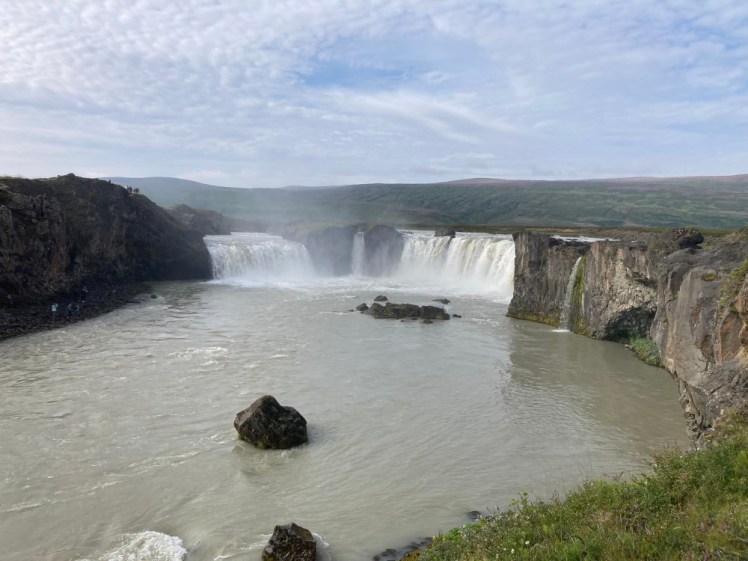
It’s a good waterfall, a horseshoe shaped ring of smaller falls, now fenced off so tourists can’t stand in the shallows two feet away from the sheer edge. It continues as a series of rapids through a shallow canyon which you can cross either by the footbridge or the road bridge and on the other side, you can scramble down the side of the canyon to water level. Having not been over there for nine years, I’m not sure whether that’s actually allowed anymore or whether the people I saw down there are now stepping over fences. Tourists tend to gather around the horseshoe, which is the obviously spectacular bit, but if you follow the paths as they wind their way down to the bridges, there are some equally amazing but very different bits of rushing and falling water which you’ll probably have to yourself.

Stop three was at Husavik, which is a nice little fishing town on the north coast which has made a name for itself as the whale watching capital of Iceland. If you’re not watching whales, you may find there’s not a lot to keep you here for long, unless you’re going to Geosea, the clifftop hot pools opened a few years ago. On the other hand, if you’re a fan of the star-shaped crisps in sour cream flavour, there’s an entire shelf of them at the Netto here. So I stocked up on my favourite crisps, strolled the harbour for half an hour and then headed onwards

Now we’re getting onto the big Diamond Circle stops. Ásbyrgi is pretty spectacular although I’d forgotten how far it is along the north coast from Husavik – about three-quarters of an hour to the turning. It’s a pretty spectacular and surprisingly lonely stretch of road considering this is the north’s answer to the south’s Golden Circle. What I’ve concluded after thinking hard about things is that there are two kinds of tourist in the north. The first are people like me, doing the Ring Road, and as I’ve observed before, a lot of them skip over the majority of the north because the south is more obviously interesting or at least more obviously Instagrammable. The second are tour coaches coming from cruise ships and so perhaps if you time it right, if the cruise ships aren’t in Husavik or Akureyri, or you’re running on a different timetable to them, you may not come across them.
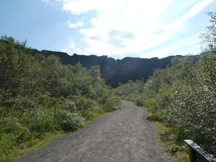
Ásbyrgi is a horseshoe shaped cliff up to 100m tall. Some legends say it’s a hoofprint from Odin’s eight-legged steed Sleipnir. Those of a more scientific persuasion say that it was caused by a glacial flash flood. I’ve stood and stared at it and tried to imagine it. The open end of the hoof faces north, upriver. I just can’t fathom how it would happen, not in that direction. Now, what I can imagine is that this was once a big waterfall, now dried up after the river altered its course. But that’s not what the experts say and I’m far from an expert. You drive about three and half kilometres from the main road, the road getting narrower, rougher and a lower speed limit all the way until you reach the car park half-hidden under the trees. Then you’re free to wander the paths in the birch forest filling in the horseshoe as much as you like. Further back, there’s a big bit of rock, another cliff, filling in half the gap between Ásbyrgi’s sides like an island, which is why it’s called the Island. If you can figure out where to park, you can stroll up the Island and get some spectacular views of Ásbyrgi’s sheer walls from there. Otherwise, as you stroll through the forest, you’ll find natural viewpoints up a bit closer.
There’s a big pond along the base of the cliffs right in the end of the horseshoe. Its name is Botnstjörn and there’s a fairly new-looking viewing platform for looking at fish and cliffs just a few metres away. If you keep following the path, you can climb up to another viewing platform in the western end of the pond and onwards to a natural viewpoint about halfway up the cliff. Neither are great for big-picture photos of Ásbyrgi but both will give you amazing views of this bit of nature and a sense of how high the cliffs are and how far they stretch.

The most spectacular stop on the Diamond Circle is Dettifoss. There are two banks and two roads – once you’re committed to one, there’s no changing your mind. The western side is quite green and accessed by the road 862, which is a little over a kilometre back towards Husavik from the Ásbyrgi turning. I don’t know about the northern end of it but I’m given to understand that the southern end of it is paved and it’s here that you’ll go if you take a tour.
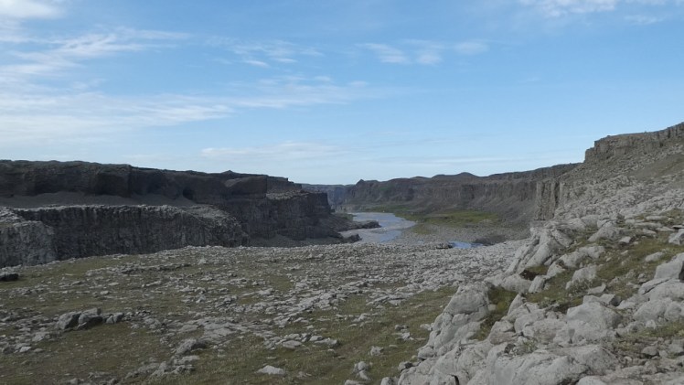
I prefer the eastern side, which is very grey and very rocky and lets you look right into the face of Dettifoss, which is one of the most powerful waterfalls in Europe, rivalled only by Switzerland’s Rhinefalls (which didn’t strike me as very powerful when I visited them back in 2006). The downside is that the road here, the 864, is entirely unpaved and very rough the entire way, from the north here to Dettifoss and onwards to the Ring Road. It’s a little under 3km east of the Ásbyrgi turning, just on the other side of the steel bridge that crosses the fairly deceptively calm northern end of the river which Dettifoss is in.
Both roads come out a couple of kilometres apart on the Ring Road east of Myvatn. The 862 is about 50km long whereas the 864 is about 54km because it bends at the end to avoid the river. The only amenities on either are the toilets at Dettifoss; otherwise, you’re just driving across lava field. On the eastern road, the speed limit is 80kph but unless you’re confident in your ability to drive on a narrow, slippery, dusty gravel road with frequent blind humps, don’t calculate your time based on anything faster than 50kph, if that.
These days, the rocky landscape on the eastern side of the gigantic waterfall is marked out into paths with stakes and ropes. The idea is partly to stop tourists blithely walking into the shallows of the waterfall, as I muttered out loud to myself, followed by “What did I just say?” as a tourist in a yellow raincoat ducked under the ropes to go and stand on the edge of the raging torrent while a camera on a tripod watched her.

When no one’s being stupid, this is an incredible place to watch the waterfall. It’s greyish-gold because it comes from Vatnajökull and has picked up a lot of sediment along the way. That means when it falls over the 44m cliff, it looks a bit like a giant beige cable-knit jumper. Its average flow rate is 193 m³/s and in spate, it can throw 500m³ of water over every second. To use the usual Olympic swimming pool, analogy, that’s an entire Olympic swimming pool every five seconds. You absolutely do not want to get as close as some tourists do and risk being thrown down with it.

Following the marked paths, I walked along the edge of the canyon and discovered a second viewpoint a couple of hundred metres along which lets you see right down into the bottom of Dettifoss’s canyon. You can’t actually see the bottom of the waterfall itself because of the amount of spray it sends up but I’ve been here two or three times before and it feels weirdly private to get to see it from that angle, like you’ve strayed into somewhere you shouldn’t. What else you can see from here is the opposite bank becoming less green and more grey the further from the waterfall as the spray thins out. Further up, the rocks on the bank and in the canyon make this look like a scene from a post-apocalypse movie and one day I’m going to write a book with at least a couple of scenes set right here, in this grey wilderness. Perhaps it isn’t to everyone’s taste but there’s something about the vast bleakness that I really like.
Another hour or so on the rough road and I found myself back on the Ring Road, heading west to Myvatn for a day or two. But there were still two more stops on my unbirthday adventure. Number one was a crater just off to the left of the road called Hrossaborg. It’s shaped a bit like a saddle, sunken in the middle, and I love it. If you’ve seen the Tom Cruise film Oblivion, it plays the part of a baseball stadium. Now, minor problem: Hrossaborg stands three-quarters of a kilometre into an F-road, a mountain road with lava and rivers to cross, which it’s illegal to drive my campervan on. There are no hazards on those 700m to the Hrossaborg turning, or none worse than I’d encountered on the eastern Dettifoss road but the fact is that it’s illegal and “the police have their own surveillance”, as the hire company woman said when I asked if it’s true that they track their vehicles to make sure they don’t drive on F-roads. So I parked in the little car park on the corner where there are information boards, just before the F-road starts and I hiked up that road to see the crater. There were some men there with a broken-down monster truck who must have wondered what on earth I was doing as I strode out into the Highlands in nothing but a flannel shirt with my keys and phone in my pocket. I walked along that road, leaping into the soft grey sand to the side once when a small 4×4 came racing past (and didn’t stop to ask what I was doing or where I was going!) until I got to the Hrossaborg turning. I didn’t walk all the way into the crater – the path crosses something that didn’t look very inviting but I got close enough to take some photos and enjoy it before hiking back.

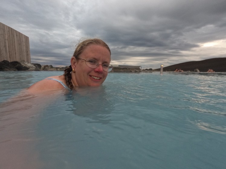
And last, you can’t do the Diamond Circle or find yourself in the Myvatn area without going to the Myvatn Nature Baths. It’s everything good about the Blue Lagoon magically improved. It’s the same milky white-blue water from a power station (except that it’s Krafla power station instead of Svartsengi), it’s the same large irregular-shaped lagoon, it’s the same temperature, the same weirdly silky texture, the same crackling noise if you stick your ears underneath, but it’s much smaller, much quieter and much cheaper. Of course, it’s got some disadvantages too. The changing rooms are a bit more rustic and there are no electronic wristbands for buying drinks at the in-water bar.

I’m a big fan of its setting, halfway up the orange-streaked slopes of the active volcano above the lake, so that you can look down towards the lake in one direction and up at the volcano in the other. The trouble is that Myvatn Nature Baths are currently expanding – not only making the lagoon bigger but building a new service building, which is presumably going to be more modern than the old one as well as bigger. When I was here in 2023, there were signs up saying that it was due to open in the summer of 2024 and I was vaguely disappointed that I couldn’t come to Iceland that year (I mean, there’s only so disappointed you can be when the reason is that you’re going on a big train adventure to Poland to see Taylor Swift) so I was astounded to arrive in the summer of 2025 to no major changes and signs saying it’s due to open the summer of 2026. I’m genuinely looking forward to seeing the result, I’m just not sure how much faith I have in it actually being next summer.

Vagaries of building work aside, I enjoyed my evening at the Nature Baths. The second lagoon, the one through the gap where it’s a lot quieter, felt unusually cold for a pool that’s often unbearably hot but I’m going to put that down to the Earth not necessarily being a 100% reliable thermostat. I was surprised but where it was hot, it really was hot, the sort of hot where you scurry away as best you can in water that deep, making monkey-like “ooh ooh ooh” noises until you find a bit of water that isn’t trying to burn your skin off.
And that’s how I spent my unbirthday: Goðafoss, Husavik, Ásbyrgi, Dettifoss, Hrossaborg and Myvatn Nature Baths. I will observe that it rained when I got back to Myvatn and I hadn’t realised how dusty that road was. The rain pouring down the side of my van left a brown line underneath it and where I had the windows slightly open, everything inside the van was covered in a faint layer of grey dust, including the entire dashboard and all the food that wasn’t zipped away inside my food bag. To be honest, I’m not sure closing the windows would have done a lot of good. But it was a great way to spend a day and a better way to spend a birthday, even if it technically wasn’t.


One thought on “An unbirthday on Iceland’s Diamond Circle (North Iceland part 2)”