I found a volcano by the side of the road and I climbed it. Meet Grábrók.
Last year, I hired a car and spent ten or eleven days around the east and north of Iceland. Somewhere around Day Six I drove from Borgarnes to Akureyri. Borgarnes is a small town – a service centre, really – on the west coast and my favourite place in all of Iceland. If I ever move to Iceland, I want to live in Borgarnes. Akureyri is Iceland’s second city, a small town by other countries’ measures, in the north. It’s a journey of 196 miles from one bed to the next and a drive I was a bit nervous about, given that I’d just spent twenty-four hours lying on a bed in Borgarnes watching the ceiling spin, which I’m blaming on an ear infection. The idea of driving for four hours with dizziness waiting to strike wasn’t an appealing one but I’d started to feel better in the evening and had successfully walked a circle around the headland, so I thought if I took it slowly and gently I’d be ok.
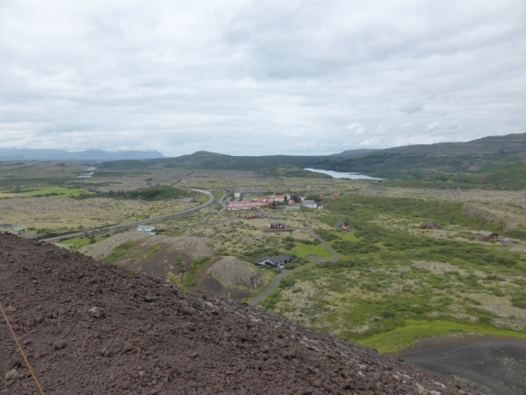
Twenty miles north of Borgarnes, along the Ring Road, is Bifröst, a university settlement not even large enough to merit the name of “village”. Bifröst also being the name of the rainbow bridge that joins Midgard and Asgard in the Norse myths, I liked the idea of pausing there to take a photo with the town sign, which I never managed to spot. Maybe it’s not big enough to merit one of those either. What I did spot was a volcano.
Grábrók is one of three young scoria craters, only about three thousand years old. I don’t know exactly what scoria means, only that it’s some kind of volcanic rock but in my experience, any volcano that’s streaked with red is scoria. Scoria volcanoes are very pretty, being red and black and usually with contrasting grey-green moss growing on it – all very decorative. These particular craters are the easternmost craters of the Ljósufjöll system, on the Snæfellsnes peninsula. The Ljósufjöll central volcano is around twenty-five miles away as the crow flies. Wikipedia says it’s the only volcanic system on Snæfellsnes that has erupted in recorded history and it killed eighty people but let’s blame that on the western end of the system rather than the eastern end.
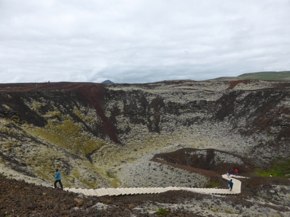
Anyway. The smallest of these three craters has been more or less mined into extinction but the two larger are still intact and one of them, Stóra Grábrók (Big Grábrók), is not only still intact but it also has a hiking trail built on it. Well, what was I supposed to do? I parked my car, packed whatever I would need to climb a volcano (with no regard whatsoever for the fact that this is a tiny volcano that the whole family scurries up to have a look at the view for ten minutes before moving on – I took three cartons of juice plus food for the journey!), put on my scrambling shoes and set off.
You follow a path up the saddle-shaped south-eastern side of the crater, then there’s a boardwalk around the top. The timer on my photos shows less than thirty-five minutes between taking a photo of the information board at the bottom and taking photos of my car again afterwards, so that’s how long it takes – a very quick and easy walk to enjoy the view and the experience of climbing a volcano. But you don’t need to take a picnic with you.